place

Sunland Park, New Mexico

Cities in Doña Ana County, New MexicoCities in New MexicoMexico–United States border crossingsNew Mexico populated places on the Rio GrandeUse mdy dates from January 2024
Sunland Park Statue
Sunland Park Statue

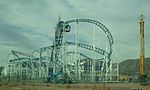
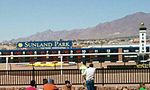
Sunland Park is a city in southern Doña Ana County, New Mexico, United States, on the borders of Texas and the Mexican state of Chihuahua, with Ciudad Juárez adjoining it on the south and El Paso, Texas, on the east. The community of Santa Teresa adjoins it on the northwest. The population of Sunland Park was 14,106 at the 2010 census and was estimated at 17,978 by the United States Census Bureau in 2019. Though it lies adjacent to El Paso, being in Doña Ana County makes it a part of the Las Cruces metropolitan statistical area. Las Cruces is 42 miles (68 km) to the north. The city is at the foot of Mount Cristo Rey, next to the Rio Grande, and is named for Sunland Park Racetrack & Casino, which lies within the city limits. The location was formerly called "Anapra", a name shared by an adjacent area of Ciudad Juárez.

Excerpt from the Wikipedia article Sunland Park, New Mexico (License: CC BY-SA 3.0, Authors, Images).

Sunland Park, New Mexico

Geographical coordinates (GPS) Address Nearby Places
placeShow on map

Wikipedia: Sunland Park, New MexicoContinue reading on Wikipedia

Geographical coordinates (GPS)

Latitude Longitude
N 31.806666666667 ° E -106.58 °
placeShow on map

Address


88063
New Mexico, United States
mapOpen on Google Maps

Sunland Park Statue
Sunland Park Statue
Share experience

Nearby Places

Coronado High School (El Paso, Texas)

Coronado High School in El Paso, Texas, United States is located on the west side of El Paso near the intersection of North Mesa Street and Resler Drive. It serves the southern part of west El Paso: east of Interstate 10, from the vicinity of Executive Center Boulevard north approximately three miles to around Coronado Arroyo, a normally dry stream bed running west down from the Franklin Mountains just north of Escondido Drive; and the portion of the Upper Valley (the part of El Paso County beside the Rio Grande west of Interstate 10) which lies south of Country Club Road. Most of the Coronado attendance zone is zoned to Morehead Middle School for grades six to eight. The elementary schools in the Coronado feeder pattern include Dr. Green, L.B Johnson, Putnam, Carlos Rivera, Western Hills, and Zach White. The Upper Valley portion of the Coronado attendance area is zoned to Zach White Elementary and Lincoln Middle School, except for the Buena Vista neighborhood around Interstate 10 and West Paisano Drive, which is zoned to Johnson and Morehead. Dr. Green, L.B Johnson, Putnam, Carlos Rivera and Western Hills elementary schools all graduate into Morehead Middle School. Notes for the high school feeder zone have schools name changed. Since EPISD 2016, Bond passed for the school consolidated for the following: Don Haskins PK-8 served in the Upper Valley, known as former Abraham Lincoln Middle School. There are two elementary schools for Oran Robert Elementary School, and Mitzi Bond Elementary School is closed. Charles Q Murphree PK-8 served in the Westside El Paso across Mesa Street, known as former Morehead Middle School. There is one elementary school for LB Johnson Elementary school is closed.Coronado High is named for Spanish conquistador Francisco Vázquez de Coronado, whose expeditions in what is now the southwestern United States took him through what is now El Paso.