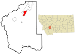
Clancy, Montana
Census-designated places in Jefferson County, MontanaCensus-designated places in MontanaHelena, Montana micropolitan areaUse mdy dates from July 2023

Clancy is an unincorporated community and census-designated place (CDP) in Jefferson County, Montana, United States. The population was 1,661 at the 2010 census, up from 1,406 in 2000. It is part of the Helena Micropolitan Statistical Area. The town was founded in 1873 as a gold camp and named for prospector William Clancey. A fire in 1902 destroyed many of the buildings in town.
Excerpt from the Wikipedia article Clancy, Montana (License: CC BY-SA 3.0, Authors, Images).Clancy, Montana
Chokecherry Lane,
Geographical coordinates (GPS) Address Nearby Places Show on map
Geographical coordinates (GPS)
| Latitude | Longitude |
|---|---|
| N 46.474722222222 ° | E -111.98361111111 ° |
Address
Chokecherry Lane
Chokecherry Lane
59638
Montana, United States
Open on Google Maps


