place

Battle of San Pasqual
1846 in Alta California1846 in the Mexican-American WarBattles of the Conquest of CaliforniaDecember 1846 eventsEvents in San Diego County, California
Source attributionUnited States Marine Corps in the 18th and 19th centuries
SanPasqual
SanPasqual

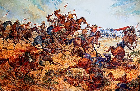
The Battle of San Pasqual, also spelled San Pascual, was a military encounter that occurred during the Mexican–American War in what is now the San Pasqual Valley community of the city of San Diego, California. The series of military skirmishes ended with both sides claiming victory, and the victor of the battle is still debated. On December 6 and December 7, 1846, General Stephen W. Kearny's US Army of the West, along with a small detachment of the California Battalion led by a Marine Lieutenant, engaged a small contingent of Californios and their Presidial Lancers Los Galgos (The Greyhounds), led by Major Andrés Pico. After U.S. reinforcements arrived, Kearny's troops were able to reach San Diego.

Excerpt from the Wikipedia article Battle of San Pasqual (License: CC BY-SA 3.0, Authors, Images).

Battle of San Pasqual
San Pasqual Valley Road, San Diego San Pasqual Valley

Geographical coordinates (GPS) Address Nearby Places
placeShow on map

Wikipedia: Battle of San PasqualContinue reading on Wikipedia

Geographical coordinates (GPS)

Latitude Longitude
N 33.086111111111 ° E -116.99 °
placeShow on map

Address

San Pasqual Valley Road
San Diego, San Pasqual Valley
California, United States
mapOpen on Google Maps

SanPasqual
SanPasqual
Share experience

Nearby Places

San Pasqual, San Diego County, California

San Pasqual, the Kumeyaay pueblo, in San Diego County, California, that was once located in the San Pasqual Valley and for which the valley is named. In pre-Hispanic times the Kumeyaay had lived for centuries in the San Pasqual Valley. Following the closing of the missions by the Mexican government in 1833, the Kumeyaay moved back to their San Pasqual Valley and the Kumeyaay pueblo of San Pasqual was established on November 16, 1835.The village of San Pasqual was a stop on the road between San Diego and Sonora from the late 1820s. The road ran from San Diego to Rancho Santa Maria de Los Peñasquitos then 16 miles to the village, then turned south and up to the ridge line bordering the south side of the valley, then eastward into the Santa Maria Valley (through what became Rancho Valle de Pamo, and later modern Ramona) and on to Santa Ysabel for a distance of 18 miles. The road went on to San Jose Valley, Vallecito, across the Colorado Desert, to cross the Colorado River into Sonora. From the time of the California Gold Rush San Pasqual became a stop on the main road for wagon and stagecoach traffic following the American Conquest of California.The Kumeyaay of San Passqual were evicted from their land and homes in 1878 by San Diego County authorities. They have become known as the San Pasqual Band of Diegueno Mission IndiansThe only remnant of the village is the small graveyard east of the San Diego Acheological Center on the north side of State Highway 78.

San Diego Zoo Safari Park

The San Diego Zoo Safari Park, originally named the San Diego Wild Animal Park until 2010, is an 1,800 acre (730 ha) zoo in the San Pasqual Valley area of San Diego, California, near Escondido. It is one of the largest tourist attractions in San Diego County. The park houses a large array of wild and endangered animals including species from the continents of Africa, Asia, Europe, North and South America, and Australia. This includes the largest collection of hoofed mammals in the world. The park is in a semi-arid environment, and one of its most notable features is the Africa Tram, which explores the expansive African exhibits. These free-range enclosures house such animals as antelopes, giraffes, buffalo, cranes, and rhinoceros. The park is also noted for its California condor breeding program. The park, visited by 2 million people annually, houses 3,000 animals representing roughly 400 species, as well as 3,500 plant species.Depending on the season, the park has about 400 to 600 employees. The park is also Southern California's quarantine center for zoo animals imported into the United States through San Diego. The park has the world's largest veterinary hospital. Next door to the hospital is the Institute for Conservation Research, which holds the park's Frozen Zoo. This zoological park and the San Diego Zoo are both run by the nonprofit San Diego Zoo Wildlife Alliance. The park is 32 miles (51 km) away from the zoo, east of Escondido, California, along California State Route 78. The park is primarily within the San Diego city limits, with an Escondido mailing address.

Rincon del Diablo, California

Rincon del Diablo is a community in San Diego County, California. Because it predates Escondido and other geopolitical boundaries, it does not necessarily correspond to present day definitions. Western and northern parts of the community contain low-density semi-rural housing. Southeastern part is agricultural. The Orfila winery is located on the border between Rincon del Diablo and San Diego. The community is divided between zip codes 92025 and 92027. The area code is 760. In part, is within the "sphere of influence" of Escondido, and therefore those parts may eventually be annexed to the city. Current city policies prevent the city from actively seeking annexation of new land and require property owners to petition to be annexed, a slow and expensive process.It shares the name with the original Rancho Rincon del Diablo that included the city of Escondido and surrounding areas in the 19th century. Rincon del Diablo means "Corner of the devil or where evil ones abide" in Spanish referring to lands outside Christianity or unenlightened - a dark place to fear. In reference to the beliefs of that period being what is not of Christians belongs to evil. The full name was likely shortened to simply Rincon del Diablo as the Rancho identified this specific place whereas Spanish maps of the lands known labeled the unknown as harboring evils. The United States Census Bureau does not provide demographic estimates for the community. Rincon Del Diablo includes census tract 207.06 of San Diego County. According to SANDAG estimates, total population of census tract 207.06 is 6,159 people. Median household income is $116,487. 19.2% are under the age of 18 and 17.3% are over 65. Median age is 46.1 years. Ethnic makeup is 76.5% non-Hispanic White, 15.7% Hispanic, 4.4% Asian / Pacific Islander. In 2008, there were 4,572 registered voters in the community.