place

St. Johns River Veterans Memorial Bridge

1960 establishments in FloridaBridges completed in 1960Bridges completed in 2004Bridges in Seminole County, FloridaBridges in Volusia County, Florida
Bridges on the Interstate Highway SystemBridges over the St. Johns RiverConcrete bridges in the United StatesFlorida building and structure stubsFlorida transportation stubsGirder bridges in the United StatesMonuments and memorials in FloridaRoad bridges in FloridaSouthern United States bridge (structure) stubs
Sanford FL I 4 bridge01

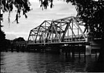
The original St. Johns River Bridge was a four-lane concrete-and-steel causeway bridge constructed over the St. Johns River at the west outlet of Lake Monroe. It is a part of Interstate 4, and spans the border between Seminole and Volusia Counties in Florida, United States. On the Seminole side is Sanford and on the Volusia side is DeBary. The bridge's design, which lacked shoulders for disabled or wrecked vehicles to pull out of the flow of traffic, made it a severe bottleneck for commuters going to the Orlando Area beginning in the 1980s. A series of fatal traffic collisions on it and similarly-designed bridges statewide, most notably the Interstate 75 Lake Panasoffkee Bridge, led to a move in 2000 to use state emergency bridge funds similar to the contingency funds used to rebuild the Sunshine Skyway Bridge to begin planned reconstruction. Work began in 2001, and a new dual structure consisting of two three-lane spans, each with wide shoulders on either side, was fully opened in May 2004. The old bridge was dismantled over the next few months. Upon completion, the new structure was officially renamed the St. Johns River Veterans Memorial Bridge.

Excerpt from the Wikipedia article St. Johns River Veterans Memorial Bridge (License: CC BY-SA 3.0, Authors, Images).

St. Johns River Veterans Memorial Bridge
I 4,

Geographical coordinates (GPS) Address Nearby Places
placeShow on map

Wikipedia: St. Johns River Veterans Memorial BridgeContinue reading on Wikipedia

Geographical coordinates (GPS)

Latitude Longitude
N 28.8358 ° E -81.3192 °
placeShow on map

Address

I 4
32747 , DeBary
Florida, United States
mapOpen on Google Maps

Sanford FL I 4 bridge01
Share experience

Nearby Places

DeBary station
DeBary station

DeBary station is a train station in DeBary, Florida. It is the current northern terminus of Phase 1 of SunRail, the commuter train serving Central Florida. The station opened May 1, 2014, and marks the return of passenger rail service to the DeBary area, which previously operated from Benson Junction further to the north. The station is currently the northern terminus of SunRail until Phase 2 North is completed in the future. DeBary is typical of most SunRail stations featuring canopies consisting of white aluminum poles supporting sloped green roofs and includes ticket vending machines, ticket validators, emergency call boxes, drinking fountains, and separate platforms designed for passengers in wheelchairs. The station is located along the former CSX A-Line (originally constructed by the Jacksonville, Tampa and Key West Railway) along the west side of US 17/92 just north of the Lake Monroe drawbridge. Due to ridership of over 10,000 on the first two days of service, the parking facilities quickly filled up leading Volusia County to start two free shuttle services, one from nearby Gemini Springs Park and another from Deltona Plaza at 1200 Deltona Blvd, Deltona. The free shuttles ended on May 16, 2014, coinciding with the end of free Sunrail service. Regular Votran bus routes 30, 31, 32, and 33 will continue to serve the DeBary station. A transit-oriented development called Integra 289 Exchange, which will feature a four-story, 289-unit luxury apartment community, is currently planned to be built adjacent to the station.