Mark Clark Bridge

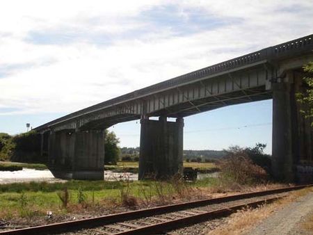
The Mark Clark Bridge was a girder bridge that carried a State Route 532 across the Stillaguamish River between Stanwood, Washington, and Camano Island. It was the only form of road access to Camano Island from 1950 until 2010, when it was demolished. The bridge was named for Mark W. Clark, a decorated Army officer who spent time on Camano Island. The water surrounding Camano Island is too shallow for ferry service, which made this bridge a critical link for island residents and visitors.The bridge replaced an earlier swing bridge that opened in 1909 and was part of the first highway between Stanwood and Camano Island. Shortly after the highway was incorporated into the state highway system in 1945, a $615,000 replacement was planned by the state government at the request of Stanwood, Camano Island, and the former town of East Stanwood. It was dedicated on July 23, 1950, and was connected to a new highway bypassing Stanwood and East Stanwood.
Excerpt from the Wikipedia article Mark Clark Bridge (License: CC BY-SA 3.0, Authors, Images).Mark Clark Bridge
State Route 532,
Geographical coordinates (GPS) Address Nearby Places Show on map
Geographical coordinates (GPS)
| Latitude | Longitude |
|---|---|
| N 48.240266 ° | E -122.383189 ° |
Address
State Route 532 11203
98292
Washington, United States
Open on Google Maps


