place

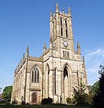
Bury Hebrew Congregation

Bury, Greater ManchesterOrthodox synagogues in EnglandReligion in Greater ManchesterSynagogues in Manchester

Bury Hebrew Congregation, also known as Bet Knesset Sha'ar HahShamayim (Gate of Heaven Synagogue) is an Orthodox synagogue, serving the Jewish community in the Sunnybank, Unsworth and Hollins area of North Manchester.

Excerpt from the Wikipedia article Bury Hebrew Congregation (License: CC BY-SA 3.0, Authors).

Bury Hebrew Congregation
Sunny Bank Road,

Geographical coordinates (GPS) Address Nearby Places
placeShow on map

Wikipedia: Bury Hebrew CongregationContinue reading on Wikipedia

Geographical coordinates (GPS)

Latitude Longitude
N 53.562883 ° E -2.290864 °
placeShow on map

Address

Bury Hebrew Congregation

Sunny Bank Road
BL9 8HE , Blackford Bridge
England, United Kingdom
mapOpen on Google Maps

Share experience

Nearby Places

Whitefield, Greater Manchester

Whitefield is a town in the Metropolitan Borough of Bury, Greater Manchester, England. It lies on undulating ground above the Irwell Valley, along the south bank of the River Irwell, 3 miles (4.8 km) southeast of Bury, and 5 miles (8.0 km) northwest of Manchester. Prestwich and the M60 motorway lie just to the south. Historically part of Lancashire, Whitefield was on the path of an ancient Roman road leading from Mamucium (Manchester) in the south to Bremetennacum (Ribchester) in the north. Throughout the Middle Ages, Whitefield was a division of the township of Pilkington, itself a part of the parish of Prestwich-cum-Oldham and hundred of Salford. Pilkington and Whitefield have historic associations with the Earls of Derby. Farming was the main industry of this rural area, with locals supplementing their incomes by hand-loom woollen weaving in the domestic system. The urbanisation and development of Whitefield largely coincided with the Industrial Revolution. The name Whitefield is thought to derive from the medieval bleachfields used by Flemish settlers to whiten their woven fabrics, or else from the wheat crop once cultivated in the district. The construction of a major roads routed through the village facilitated Whitefield's expansion into a mill town by the mid-19th century. Whitefield became a local government district in 1866, and was governed by a local board of health until 1894, when the area of the local board became an urban district.