place

Sint-Oedenrode

Former municipalities of North BrabantMeierijstadMunicipalities of the Netherlands disestablished in 2017Populated places in North Brabant
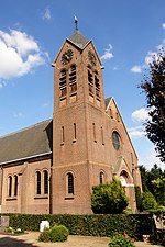
Kerkplein, Sint Oedenrode (Sint Martinuskerk)

Sint-Oedenrode (Dutch pronunciation: [sɪnt ˈudə(n)roːdə] (listen)) is a town in the province of North Brabant. Sint-Oedenrode is a moderately urbanized town in the Meierij of 's-Hertogenbosch. Sint-Oedenrode had an unknown population as of 2021 and has an area of 64.94 km2 (25.07 sq mi). On 1 January 2017 Sint-Oedenrode, together with Schijndel and Veghel, merged into a new municipality called Meierijstad creating the largest municipality of the province North-Brabant in terms of land area.The municipality traditionally had "vrijheidsrechten" (a predecessor of city rights), since 1232, until the abolishment of the privileges and introduction of the Municipalities Act in 1851. In those feudal times Sint-Oedenrode was referred to as a "Vlek" (market town). Today it is still a large town. From southeast to northwest, the town is split by the river Dommel.

Excerpt from the Wikipedia article Sint-Oedenrode (License: CC BY-SA 3.0, Authors, Images).

Sint-Oedenrode
Achterpad, Meierijstad

Geographical coordinates (GPS) Address Nearby Places
placeShow on map

Wikipedia: Sint-OedenrodeContinue reading on Wikipedia

Geographical coordinates (GPS)

Latitude Longitude
N 51.566666666667 ° E 5.4666666666667 °
placeShow on map

Address

Scouting Rooi

Achterpad 3
5491 GV Meierijstad
North Brabant, Netherlands
mapOpen on Google Maps

Kerkplein, Sint Oedenrode (Sint Martinuskerk)
Share experience

Nearby Places

Dommelbeemden
Dommelbeemden

The Dommelbeemden are, along with the Moerkuilen a forestry area in a bend of the Dommel river northeast of Nijnsel in Meierijstad. It is located at the Lieshoutse Dijk, not far from the A50 motorway. The protected area measures over 100 acres. The Dommelbeemden are part of the larger area Het Groene Woud.This diverse area was designated as a natural monument in 1977. The most original part and natural state of the Dommel can be found between Eindhoven and Boxtel and hence in the Dommelbeemden. Here the Dommel has still its original winds and meanders and forms a cultural-historical and valuable landscape area. The Dommelbeemden consist of species-poor meadows with willows and include rattles and orchids. There are wet meadows in which rare plants such as Marsh Lousewort can be found. A clogging old meander of the Dommel there is filled with water lilies. At a higher elevation, which is part of the Central Brabant Sand Ridge, there are traditional "bolakkers" (high fields). The meadows are the low-lying grasslands directly along the Dommel. Through regular flooding these grounds were once only suitable as a hayfield. This hay was important because it served as winter feed for livestock. Originally, this landscape was interspersed with carrs and coppice hedges. On the upper parts of the river valley, there are bolakkers (high fields) where mainly cereals were cultivated. The area is known to have rare plants and animals.In the southeast the area connects with the Vresselse Bossen. The current management is aiming to restore the old landscape of the area as much as possible. The meadows are extensive grazed and Staatsbosbeheer replanted hedges and knotted willows.

Vresselse Bossen

East of the village of Nijnsel and the hamlet of Vressel, both in Meierijstad, North Brabant, Netherlands, is the location of the Vresselse bossen or Vresselsche Bosch (Vressels Forest). The Vresselse Bossen is a forest area of 241 ha. It is owned and managed by the National Forest Service (Staatsbosbeheer). The forest is named after the nearby hamlet of Vressel. It is a young forest that planted in a drift-sand ridge. At the beginning of the 20th century, there was scarcely a tree in the area. The area consisted mainly of dunes and heathland. At the edges of the area lived farmers who were severely affected by the shifting sands. To protect the fields was therefore decided to reforest the drift-sand. At that time, almost exclusively pine was used for the reforesting. In the twenties of the 20th century, it had become a production forest consisting of Scots pine for the Limburgian mines. Within the area, there are two main fen systems: The Hazenputten and the Oude Putten. Rare vegetation is found around the fens: among others White beak-sedge and bog asphodel can be found here. The contemporary management by Staatsbosbeheer focuses on getting a more varied forest composition, including native oak, linden and beech. To prevent the Hazenputten from drying, competing for vegetation is removed around the pools. The area around the marshes has been grazed by Highland cattle and Exmoor horses in the past. The area has a rich bird population. Breeding birds are: yellowhammer, kingfisher, black woodpecker, northern goshawk, little grebe, European green woodpecker, common buzzard, great egret, long-eared owl, coal tit, little owl, barn owl and crested tit. Also many species of mammals can be encountered: These include: roe deer, European badger, Eurasian harvest mouse, European polecat, European water vole, European hedgehog, Eurasian red squirrel, common pipistrelle, European hare, brown long-eared bat, stoat, serotine bat, European mole, Natterer's bat, least weasel, red fox, Daubenton's bat, beech marten and several species of shrew, dormice, apodemus and arvicolinae. The "Hazenputten" was nominated by Staatsbosbeheer for the title of "Most beautiful spot" in the Netherlands in 2013.The Vresselse Bossen are part of Het Groene Woud, a vast nature area between Eindhoven, Den Bosch and Tilburg. West of the Vresselse Bossen lies the valley of the Dommel; in the northwest, the Vresselse Forest reaches the Moerkuilen. To the north, there is the reclaimed heathland of the Jekschot Heath and to the east lies the DAF test track and Mariahout Forest.