place

Maarn

Former municipalities of Utrecht (province)Municipalities of the Netherlands disestablished in 2006Populated places in Utrecht (province)Utrecht (province) geography stubsUtrechtse Heuvelrug
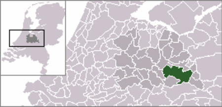
Locatie Utrechtse Heuvelrug

Maarn is a town in the Dutch province of Utrecht. It is a part of the municipality of Utrechtse Heuvelrug, and is located about 10 km east of Zeist. In 2001, the town of Maarn had 4,071 inhabitants. The built-up area of the town was 1.26 km2, and contained 1,793 residences.Until 2006, Maarn was a separate municipality, covering both Maarn and Maarsbergen. Maarn is a small village in the heart of the Utrechtse Heuvelrug, a protected nature reserve in the Netherlands. The village has approximately 8,000 inhabitants, has a very small center and is probably best known for its tourism to the numerous camp-sites that surround the village.

Excerpt from the Wikipedia article Maarn (License: CC BY-SA 3.0, Authors, Images).

Maarn
Het Steenbeek, Utrechtse Heuvelrug

Geographical coordinates (GPS) Address Nearby Places
placeShow on map

Wikipedia: MaarnContinue reading on Wikipedia

Geographical coordinates (GPS)

Latitude Longitude
N 52.066666666667 ° E 5.3666666666667 °
placeShow on map

Address

De Koeheuvels

Het Steenbeek
3951 BM Utrechtse Heuvelrug
Utrecht, Netherlands
mapOpen on Google Maps

Locatie Utrechtse Heuvelrug
Share experience

Nearby Places

Utrecht Hill Ridge
Utrecht Hill Ridge

Utrecht Hill Ridge (Dutch: Utrechtse Heuvelrug) is a ridge of low sandhills that stretches in a direction from southeast to northwest over the Dutch province of Utrecht and over a part of North Holland. The total length of the region is about 50 km. It covers an area of approximately 23,000 hectares. The part of the ridge in North Holland is commonly called Het Gooi in Dutch, the Gooi (area) in English. On the southeastern side the ridge rises sharply from the valley of the Nederrijn (“Lower Rhine”). Here the famous Grebbeberg (“Grebbe Mountain”) forms a landmark (52 m. high) where Battle of the Grebbeberg took place in 1940 as important part of Battle of the Netherlands. The highest peak of the ridge is the Amerongse Berg (“Amerongen Mountain”) of 68 m. On the northern side the ridge continues to the shores of the Gooimeer (“Lake Gooi”). The Utrecht Hill Ridge was created 150.000 years ago as a push moraine in the Wolstonian Stage, a middle Pleistocene glacial period. Before that time the rivers Rhine and Meuse flowed more north, and created deposits of sand. The glaciers pushed these deposits in a southern and western direction. After the last Ice Age the area got overgrown with woods. In historical times the population increased and woodlands were cleared for cattle and sheep. The Utrecht Hill Ridge was then largely covered with heather and sand drifts. In the 19th and 20th century large parts of the ridge were replanted with trees again. The Utrecht Hill Ridge has given name to: Utrechtse Heuvelrug, a municipality in the southern part of the ridge, that was formed 1 January 2006 as a combination of the former municipalities of Amerongen, Doorn, Driebergen-Rijsenburg, Leersum, and Maarn. Utrechtse Heuvelrug National Park, a national park in the southern part of the region, that was established 11 October 2003. It covers 6,000 hectares.