place

Cranmore West railway station

Heritage railway stations in SomersetPages with no open date in Infobox stationRailway stations built for UK heritage railwaysSomerset building and structure stubsSouth West England railway station stubs
Use British English from March 2018
Esrengineshed
Esrengineshed

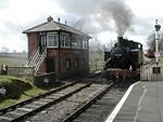
Cranmore West is a railway station on the East Somerset Railway.

Excerpt from the Wikipedia article Cranmore West railway station (License: CC BY-SA 3.0, Authors, Images).

Cranmore West railway station
Old Down Lane, Mendip Cranmore

Geographical coordinates (GPS) Address Nearby Places
placeShow on map

Wikipedia: Cranmore West railway stationContinue reading on Wikipedia

Geographical coordinates (GPS)

Latitude Longitude
N 51.184 ° E -2.483 °
placeShow on map

Address

ESR Loco Shed and Workshop

Old Down Lane
BA4 4PX Mendip, Cranmore
England, United Kingdom
mapOpen on Google Maps

Esrengineshed
Esrengineshed
Share experience

Nearby Places

Cranmore Tower
Cranmore Tower

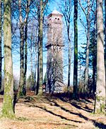
The Cranmore Tower is a 45 metres (148 ft) tall 19th century folly in the parish of Cranmore, Somerset, England. The site is 280 metres (919 ft) above sea level, and is the highest point on the Mendip Way. The tower was built in 1862-1864, by Thomas Henry Wyatt for John Moore Paget of Cranmore Hall (now part of All Hallows Preparatory School). There is a viewing area at the top with pair of semi-circular headed openings to each face with a restored iron-railed balcony beneath each pair. A similar balcony just over halfway up is continued right round the tower. It has been designated by English Heritage as a grade II listed building.In World War II it was used as a lookout tower by the Home Guard and the Royal Corps of Signals.By 1984 the tower had fallen into disrepair and was sold to Donald Beaton who undertook repairs. During the course of the repairs the remains of a Roman fort with a hoard of coins was discovered adjacent to the tower. In 1988 it was sold again, this time to Nick Ridge who opened it to the public. The tower was then acquired by followers of the Baháʼí Faith. Further restorations were carried out, including the installation of a new timber staircase to allow access to the balconies at the top of the tower at a height of 320 metres (1,050 ft) above sea level. From early 2008 the tower has been again open to the public, in particular being marketed as a romantic setting for proposals of marriage. A small fee is usually charged to ascend the tower which is open on weekends, bank and school holidays and by arrangement. Cranmore Tower and the grounds that it situated on is now privately owned and visitors are not welcomed.

St Aldhelm's Well
St Aldhelm's Well

St Aldhelm's Well in Doulting, Somerset, England, is an ancient spring which is the source of the River Sheppey. The site is a Grade II listed building, although it is a medieval site, most of what remains has been rebuilt.The well was named after St Aldhelm after he died in Doulting village in 709, some accounts say on the day of his death he sat by the well singing psalms before being carried up to the church in the village where he died. The Church of St Aldhelm in Doulting was dedicated to Aldhelm in the 8th century.Folklore has attributed healing powers to the spring water in which pilgrims were known to have bathed, the well is still visited by people who use the water and leave flowers and other offerings of reverence. The spring has never been known to fail, even in times of drought.Water flows through two low pointed arches in a stone wall in the hillside, along a bathing pool with stone sides and collapsed stone walls on each side. The carved masonry which can be seen around the site indicates the bathing pool would have once had a roof over it. The water passes through a wall to fill a stone drinking trough in the lane below, pouring over the trough's edge into a grate in the floor. The water passes under the lane into a confluence with a group of springs to the west of Doulting to become the River Sheppey, which ultimately joins the River Brue.Next to the well is a chamber containing the remains of a waterwheel which once pumped water up the hill to supply drinking water for Doulting village, a well head built in the late 19th century still stands in the village featuring a wrought-iron pump handle. The well head is also a Grade II listed building.