place

Michelbach, Altenkirchen

Altenkirchen (district)Altenkirchen district geography stubsMunicipalities in Rhineland-PalatinatePages including recorded pronunciationsPages with German IPA
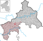
Michelbach (Westerwald) in AK

Michelbach (German: [ˈmɪçl̩ˌbax] ) is a municipality in the district of Altenkirchen, in Rhineland-Palatinate, Germany.

Excerpt from the Wikipedia article Michelbach, Altenkirchen (License: CC BY-SA 3.0, Authors, Images).

Michelbach, Altenkirchen
Südweg, Altenkirchen-Flammersfeld

Geographical coordinates (GPS) Address Nearby Places
placeShow on map

Wikipedia: Michelbach, AltenkirchenContinue reading on Wikipedia

Geographical coordinates (GPS)

Latitude Longitude
N 50.68333 ° E 7.66286 °
placeShow on map

Address

Südweg 2
57610 Altenkirchen-Flammersfeld
Rhineland-Palatinate, Germany
mapOpen on Google Maps

Michelbach (Westerwald) in AK
Share experience

Nearby Places

Battle of Altenkirchen

The Battle of Altenkirchen (4 June 1796) saw two Republican French divisions commanded by Jean Baptiste Kléber attack a wing of the Habsburg Austrian army led by Duke Ferdinand Frederick Augustus of Württemberg. A frontal attack combined with a flanking maneuver forced the Austrians to retreat. Three future Marshals of France played significant roles in the engagement: François Joseph Lefebvre as a division commander, Jean-de-Dieu Soult as a brigadier and Michel Ney as leader of a flanking column. The battle occurred during the War of the First Coalition, part of a larger conflict called the Wars of the French Revolution. Altenkirchen is located in the state of Rhineland-Palatinate in Germany about 50 kilometres (31 mi) east of Bonn. The French opened the Rhine Campaign of 1796 by ordering Kléber to attack south out of his bridgehead at Düsseldorf. After Kléber won sufficient maneuver room on the east bank of the Rhine River, Jean Baptiste Jourdan was supposed to join him with the remainder of the Army of Sambre-et-Meuse. But this was only a distraction. When the Austrians under Archduke Charles, Duke of Teschen moved north to oppose Jourdan, Jean Victor Marie Moreau would cross the Rhine far to the south with the Army of Rhin-et-Moselle. Kléber carried out his part of the scheme to perfection, allowing Jourdan to cross the Rhine at Neuwied on 10 June. The next action was the Battle of Wetzlar on 15–16 June.

Herzburg
Herzburg

The Herzburg (also sometimes the Harzburg) was a castle near the county town of Altenkirchen (Westerwald) that stood on the long hill spur between Gieleroth, Widderstein, Ingelbach and Borod. Archaeological monuments and place names give clues to the earlier settlement. The River Wied flows around this hilltop which is strategically located between the old "Cologne-Frankfurt Road" (now the B 8) and the old Cologne-Leipzig road (now the B 414). The two routes are combined from Cologne to Altenkirchen and then branch out. The Cologne-Leipzig road is also called the Cologne High Military and Escort Road (Cölnische Hohe Heer- und Geleitstraße) from Cologne to Greifenstein/Herborn on the Lahn. The mineral wealth beneath the Herzberg and the proximity of the two "High Roads" (= watershed roads) suggest that the region was inhabited in prehistoric times. A prehistoric tumulus was not removed until 1935 by the Arbeitsdienst ("labour service"). The rampart section, which was to protect the ridge from enemies, is still clearly visible. In old maps from 1820 the hill ridge of Harzburg is mentioned. But the new cadastral map refers to it as Herzberg, Herzburg and Erzburg. Several springs rise on its slopes, so that shafts on the hilltop do not have to be driven too deeply to create wells. In the Middle Ages a castle fortification was probably established on the Herzberg to guard the two highways. When, in 1300, in nearby Altenkirchen - already an important road hub - a castle was built and, in 1314, the town was fortified, the Herzburg lost its significance. Of the Herzburg all that remained was a Burgmann's farm which was outside the site on a plot of land known as Mitten auf der Herzburg ("Centre of the Herzburg"). This probably disappeared with the demise of the County of Sayn-Altenkirchen. In the surrounding villages, a legend is still told about the Herzburg.