Urban agglomeration of Montreal

Montreal is one of the administrative regions of the Canadian province of Quebec. It is also a territory equivalent to a regional county municipality (TE) and a census division (CD), for both of which its geographical code is 66. Prior to the merger of the municipalities in Region 06 in 2002, the administrative region was co-extensive with the Montreal Urban Community. Located in the southern part of the province, the territory includes several of the islands of the Hochelaga Archipelago in the Saint Lawrence River, including the Island of Montreal, Nuns' Island (Île des Sœurs), Île Bizard, Saint Helen's Island (Île Sainte-Hélène), Île Notre-Dame, Dorval Island (Île Dorval), and several others. The region is the second-smallest in area (499.26 km², or 192.77 sq mi) and most populous (1,942,044 as of the 2016 Canadian Census) of Quebec's seventeen administrative regions.
Excerpt from the Wikipedia article Urban agglomeration of Montreal (License: CC BY-SA 3.0, Authors, Images).Urban agglomeration of Montreal
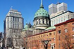
La Gauchetière Street West, Montreal Ville-Marie
Geographical coordinates (GPS) Address Nearby Places Show on map
Geographical coordinates (GPS)
| Latitude | Longitude |
|---|---|
| N 45.5 ° | E -73.566666666667 ° |
Address
Gare Centrale
La Gauchetière Street West
H5A 1L3 Montreal, Ville-Marie
Quebec, Canada
Open on Google Maps


