place

Columbia Road

Adams MorganSouthern United States road stubsStreets in Washington, D.C.Washington, D.C. stubs
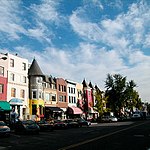
1800 block of Columbia Road

Columbia Road is a street in Washington, D.C., that forks from Connecticut Avenue north of Dupont Circle, and branches north and east through 16th Street to the McMillan Reservoir. Along its route, it marks the southern border of the Kalorama Triangle neighborhood, the principal east/west passage through the Adams Morgan neighborhood, and is one of the primary thoroughfares in the Columbia Heights neighborhood. In Adams Morgan, it is bordered by a great deal of street-level retail, constituting (with 18th Street) the main commercial area within Adams Morgan.

Excerpt from the Wikipedia article Columbia Road (License: CC BY-SA 3.0, Authors, Images).

Columbia Road
Columbia Road Northwest, Washington

Geographical coordinates (GPS) Address Website Nearby Places
placeShow on map

Wikipedia: Columbia RoadContinue reading on Wikipedia

Geographical coordinates (GPS)

Latitude Longitude
N 38.924555555556 ° E -77.039777777778 °
placeShow on map

Address

Metro Liquors

Columbia Road Northwest 1726
20009 Washington
District of Columbia, United States
mapOpen on Google Maps

Website
metrowinedc.com

linkVisit website

1800 block of Columbia Road
Share experience

Nearby Places

Lanier Heights
Lanier Heights

Lanier Heights is a small urban neighborhood located in the northwest section of Washington, D.C., and is one of the early subdivisions which were created inside the District of Columbia, but which lay outside of the original, officially-planned City of Washington. Situated two miles north of the White House, Lanier Heights is within the larger and newer neighborhood of Adams Morgan, and is usually considered to be a part of that more prominent locale. The area of Lanier Heights, just about 50 acres (20.25 hectares) in size, is bounded by 16th Street on the east, Adams Mill Road and the National Zoo on the west; Columbia Road to the south, and Harvard Street on the north. Developed mostly between 1900 and 1940, Lanier Heights consists primarily of row houses, plus a number of low- and medium-rise apartment buildings. The architecture is generally typical of the early twentieth century, in a variety of styles, especially Classical Revival. Some of the apartment houses have distinctive, well-crafted Art Deco designs. The area also contains a commercial stretch of stores on its southern side along Columbia Road. Nearby, just to the north of Lanier Heights, is the slightly older neighborhood of Mount Pleasant. Before the founding of Washington, D.C. in 1791, most of the land beneath Lanier Heights was originally part of a large, undeveloped piece of property granted in 1714 to John Bradford, who then named the tract "Plain Dealing". In 1763 this "Plain Dealing" tract was purchased by Robert Peter of Georgetown. Additionally, a small portion of the neighborhood's land came from part of a large piece of property acquired by James Holmead in 1733. Very little activity occurred on the land here until after 1800. One early structure in the area was a tavern that James Eslin built in 1826, on property that he had obtained for use as a small farm. The tavern, which quickly became a popular local gambling house, was situated near the present-day intersection of 16th Street and Columbia Road. (The Eslin tract, the eastern part of the neighborhood, was eventually developed in the 1920s.) But in general, the land that became Lanier Heights was being only lightly used—mostly (if at all) for common farming—until shortly after the end of the Civil War, when Washington started to grow with more vigor. For a time after that war, there was a small quarry, for construction stone and gravel, located along Rock Creek at the northern edge of the area. The development of the neighborhood officially began in 1883 with the creation of the “Lanier Heights Subdivision", a project planned and financed by Elizabeth Lanier Dunn and her husband General William M. Dunn. This plan’s somewhat casual street configuration was laid out just a few years before Congress decreed (in 1888) that henceforth the rectangular grid system of the central city would be continued throughout the District for all new street construction. At first the new subdivision's growth was slow. Within several years banker Archibald M. McLachlen and biologist George Brown Goode of the Smithsonian Institution had, in large part, gained control of the tract with the idea of having the neighborhood become a residential community for Smithsonian employees and other professionals in Washington. In 1897 the introduction of an electric streetcar line on Columbia Road encouraged activity. Additionally, construction of the noteworthy and attractive apartment house named The Ontario (built 1902-06) brought further attention, and people, to the area. The subdivision then developed into a fairly affluent area of families and single people, including professionals, intellectuals, and city workers. Several of the city's first housing cooperatives sprang up in Lanier Heights, including the Stafford and the Lambert (at 1789 and 1791 Lanier Place), developed by William H. Sholes, and 1705 Lanier Place, the first apartment building constructed explicitly as a cooperative. In the segregated past, it was a white neighborhood, but by the 1960s and 1970s it had become a diverse mix of people and cultures, and, for a time, a local hub of anti-establishment politics where the Black Panthers, anti-Vietnam War organizers and other activists groups resided. Recent rising home prices, however, have made it somewhat more difficult for a number of the less well-to-do residents to remain in the area. Lanier Heights is a part of the city's Ward One. And within D.C.'s Advisory Neighborhood Commission system, the area is a part of ANC 1-C.

Reed-Cooke

Reed-Cooke is a small urban neighborhood in Northwest Washington, D.C., situated within the boundaries of the larger and more prominent neighborhood of Adams Morgan, just north of the city's original L'Enfant-planned area. Its residents, and its local civic organization, the Reed-Cooke Neighborhood Association, generally consider it to be a distinct local neighborhood, although it is not on the city's list of formally recognized neighborhoods. For most official purposes, and to most Washingtonians, Reed-Cooke is a section of Adams Morgan. Located just to the west of Meridian Hill Park, Reed-Cooke is bounded by 16th Street on the east, 18th Street on the west, U St to the south, and Columbia Road to the north. This area takes its name from the two schools that sit within its borders: the H.D. Cooke Elementary School, and the Marie Reed Elementary School and Learning Center. Reed-Cooke began to develop its own identity in the 1980s as renewed citizen interest in the city was generally occurring, and the area's residents began to take a more active interest in the local neighborhood's future. This interest resulted in the creation of the "Reed-Cooke Overlay District", a zoning area formed by the city in 1991 to help conserve the existing neighborhood's composition, and to manage new development. (The Overlay District also includes a small area south of Florida Avenue, down to U Street.) Since the year 2000, and working within this zoning framework, a number of new mid-rise apartment houses and condo buildings have been constructed in the area. The land of the neighborhood was once a part of the old Meridian Hill estate of Commodore David Porter, who created that noted estate in 1816. Following the end of the Civil War, Meridian Hill's land was sold, and then subdivided in 1867, creating one of Washington's early planned subdivisions. Initially this area grew slowly, with the Reed-Cooke portion of the tract subsequently being developed in large part just after 1900. The neighborhood today continues to evolve, and is mainly composed of a mix of rowhouses and low- to mid-rise apartment buildings, in a variety of styles and sizes, from simple to elaborate. Many of the apartment buildings are condos or co-ops. There are also several stretches of light commercial buildings along Columbia Road. With the city of Washington's population continuing to grow, Reed-Cooke is also slowly growing, mostly with in-fill construction. At the end of 2017, a new boutique hotel, named The Line, opened at 1770 Euclid Street, in the northwest corner of the neighborhood. As of 2018, some residents, and some groups, are now also using the older "Meridian Hill" name when referring to the area. Reed-Cooke is a part of the District's ward 1. And within D.C.'s Advisory Neighborhood Commission system, it is a part of ANC 1-C.

Adams Morgan
Adams Morgan

Adams Morgan is a neighborhood in Northwest Washington, D.C., centered at the intersection of 18th Street NW and Columbia Road, about 1.5 miles (2.54 km) north of the White House. Notable establishments in the neighborhood include the Washington Hilton and Madam's Organ Blues Bar. Notable residential buildings include Euclid Apartments, Fuller House, Park Tower, Meridian Mansions, and the Pink Palace. Embassies in the neighborhood include the Embassy of Lithuania, the Embassy of Poland, the Embassy of the Central African Republic, the Embassy of Gabon and the Embassy of Cuba. Notable public artwork in Adams Morgan includes Carry the Rainbow on Your Shoulders, The Servant Christ, and The Mama Ayesha's Restaurant Presidential Mural. Adams Morgan is a thriving spot for nightlife and live music, particularly along 18th Street NW. Approximately 100 establishments possess liquor licenses. A moratorium on new liquor licenses has been in effect since 2000.It has been referred to as D.C.'s last funky neighborhood, although some say it is past its prime. It has also been referred to as "quirky".It is composed of rowhouses and classically-styled mid-rise apartment buildings, including many cooperatives and condominiums, along with various commercial structures. The name Adams Morgan, once hyphenated, is derived from the names of two formerly segregated area elementary schools—the older, all-black Thomas P. Morgan Elementary School (now defunct) and the all-white John Quincy Adams Elementary School, which merged in 1955 following racial desegregation.Adams Morgan is bounded: to the south by Florida Avenue NW and the Dupont Circle neighborhood to the southwest by the Duke Ellington Bridge and by Connecticut Avenue NW and Kalorama-Sheridan to the north by Harvard St. and Mount Pleasant to the east by 16th Street NW and Columbia HeightsReed-Cooke is a sub-neighborhood of Adams Morgan, consisting of the easternmost area between Columbia Road and Florida avenue.