place

Amherst Island

Important Bird Areas of OntarioIslands of Lake Ontario in OntarioLandforms of Lennox and Addington County
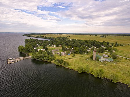
Amherst Island, Stella Village

Amherst Island is located in Lake Ontario, 10 kilometres (6 mi) west of Kingston, Ontario, Canada. Amherst Island, being wholly in Lake Ontario, is upstream, above the St Lawrence River Thousand Islands. The island is part of Loyalist Township in Lennox and Addington County. Amherst Island is located about 3 kilometres (2 mi) offshore from the rest of Loyalist Township and is serviced by public ferry from Millhaven. The Island measures over 20 kilometres (12 mi) in length from Bluff Point in the southwest to Amherst Bar in the northeast and over 7 kilometres (4.3 mi) at its widest point across. The island is about 66 square kilometres (25 sq mi) in size and is one of the largest islands in the Great Lakes. The Amherst Island archipelago also includes: Nut Island, Grape Island pronounced Grapee, the Brother Islands and Salmon Island, totalling over 6,800 hectares (16,700 acres) or about 66 square kilometres (25 sq mi). Nut Island is the largest of these islands and is about 610 metres (2,000 ft) off the Amherst Island shore between Amherst Bay and Long Point Bay. Grape Island is located about 300 metres (1,000 ft) off the Amherst Island shore, and can be easily seen from shore. The Brother Islands are situated equidistant between Amherst Island, Amherstview and Lemoine Point, Kingston, Ontario.

Excerpt from the Wikipedia article Amherst Island (License: CC BY-SA 3.0, Authors, Images).

Amherst Island
2nd Concession Road, Loyalist

Geographical coordinates (GPS) Address Nearby Places
placeShow on map

Wikipedia: Amherst IslandContinue reading on Wikipedia

Geographical coordinates (GPS)

Latitude Longitude
N 44.15 ° E -76.72 °
placeShow on map

Address

2nd Concession Road

2nd Concession Road
K0H 2S0 Loyalist
Ontario, Canada
mapOpen on Google Maps

Amherst Island, Stella Village
Share experience

Nearby Places

Amherstview, Ontario

Amherstview is an unincorporated community in the township of Loyalist, Ontario. It is located on the north shore of Lake Ontario and has a population of approximately 7,959 as of 2016. It is adjacent to the city of Kingston and is considered part of the Greater Kingston area. Amherstview is named for Amherst Island, directly to the south in Lake Ontario. When the community was first established in the 1950s, the spelling was generally "Amherst View". Amherst is a common place name found in many parts of Canada commemorating Lord Jeffrey Amherst (1717–97), Field-Marshal of the British Army, Commander-in-Chief in North America, and Governor General of British North America from 1760 to 1763.The community is the eastern end of the Loyalist Parkway, a stretch of Highway 33 that travels along Lake Ontario, in an area in which many United Empire Loyalists settled. Amherstview is home to Fairfield House which is itself situated in Fairfield Park on the shore of Lake Ontario. Fairfield House was constructed in 1793 by the Fairfield family who were among the first Loyalists to settle the area. It served as the family home and a portion of the building was also used as a tavern for some time. The impressive wood-frame building is now a museum exhibiting period artifacts and furniture and offering guided tours. Since Amherstview is part of Loyalist Township, it has no legal boundaries. General boundaries are Lake Ontario to the south, the Canadian National rail line to the north, Coronation Boulevard to the east (the City of Kingston boundary), and Lennox and Addington County Road 6 to the west.