place

Travilah, Maryland

Census-designated places in MarylandCensus-designated places in Montgomery County, MarylandMaryland populated places on the Potomac RiverUpper class culture in MarylandUse mdy dates from July 2023
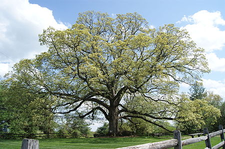
Travilah Oak April 2011

Travilah is a United States census-designated place and an unincorporated area in Montgomery County, Maryland. It is 17.28 square miles (44.8 km2) located along the north side of the Potomac River, and surrounded by the communities of Potomac, North Potomac, and Darnestown—all census-designated places. It had a population of 11,985 as of the 2020 census.Within the Travilah census-designated place at the intersection of what are now Travilah Road and Glen Road, the small rural community of Travilah existed in the late 1800s and early 1900s. The community had its own post office, general store, school, town hall, church, and a few homes. The crossroads was popular with area farmers because it was close to the Chesapeake and Ohio Canal (C&O Canal) and at least two mills. The name Travilah comes from Travilah Clagett, who was the community's first postmaster in 1883. In 2000, the United States Census Bureau began recognizing the area around the original Travilah crossroads community as a census designated place. Much of this tranquil community is simply large homes on large tracts of land with numerous parks and nature preserves mixed in. The community is within driving-distance of Washington, D.C., and the I-270 Technology Corridor. Travilah has a median household income of about $235,000.

Excerpt from the Wikipedia article Travilah, Maryland (License: CC BY-SA 3.0, Authors, Images).

Travilah, Maryland
Three Sisters Road,

Geographical coordinates (GPS) Address Website Nearby Places
placeShow on map

Wikipedia: Travilah, MarylandContinue reading on Wikipedia

Geographical coordinates (GPS)

Latitude Longitude
N 39.056944444444 ° E -77.245833333333 °
placeShow on map

Address

Glenstone Museum

Three Sisters Road
20854
Maryland, United States
mapOpen on Google Maps

Website
glenstone.org

linkVisit website

Travilah Oak April 2011
Share experience

Nearby Places

North Potomac, Maryland

North Potomac is a census-designated place and unincorporated area in Montgomery County, Maryland, United States. It is located less than 5 miles (8.0 km) north of the Potomac River, and is about 20 miles (32 km) from Washington, D.C. It has a population of 23,790 as of 2020.The region's land was originally used for growing tobacco, which was replaced by wheat and dairy farming after the soil became depleted. The Chesapeake and Ohio Canal was used by local farmers to ship their grain (or flour made from the grain at the local mills), and two former canal locks are located less than 5 miles (8.0 km) away in the Chesapeake and Ohio Canal National Historical Park. In addition, infrastructure remains for what was one of the state's leading dairy farms during the first half of the 20th century. North Potomac did not get an identity of its own until 1989, when the United States Post Office allowed the use of the North Potomac name for what is mostly a collection of housing sub-divisions, farms, and wooded parks. The United States Census Bureau listed a North Potomac in 1970 but not 1980. In 2000, it began recognizing North Potomac as a census designated place. Today, the community benefits from its proximity to workplaces such as the Shady Grove Hospital area and the I-270 Technology Corridor. Washington, D.C. is accessible by automobile or public transportation. The median household income is nearly $160,000, and nearly half of the eligible residents have a graduate or professional degree.