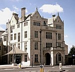
Cotham, Bristol

Cotham is an area of Bristol, England, about 1 mile north of the city centre. It is an affluent, leafy, inner city suburb situated north of the neighbourhoods of Kingsdown and St Paul’s and sandwiched between Gloucester Road (A38) to the east, and Hampton Road to the west. Cotham is closely related to the neighbourhood of Redland to the north, with the Severn Beach Railway Line broadly marking where Cotham ends and Redland begins, though Ward boundaries show Cotham extending to Redland Road. Redland’s boundaries is usually taken to extend to Coldharbour Road. To the north lies Bishopston and Westbury Park, and Durdham Down to the west. Cotham and Redland together make up the Bristol City Council's Cotham and Redland Conservation Area.It is also the name of a council ward of the city, which also includes other areas.
Excerpt from the Wikipedia article Cotham, Bristol (License: CC BY-SA 3.0, Authors, Images).Cotham, Bristol
Trelawney Road, Bristol Cotham
Geographical coordinates (GPS) Address Nearby Places Show on map
Geographical coordinates (GPS)
| Latitude | Longitude |
|---|---|
| N 51.4653 ° | E -2.6012 ° |
Address
Trelawney Road 57
BS6 6DY Bristol, Cotham
England, United Kingdom
Open on Google Maps


