Kieler Förde
Bays of Schleswig-HolsteinFörden of GermanyKielSchleswig-Holstein geography stubs

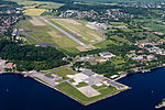
Kieler Förde is an approximately 17 km (11 mi) long inlet of the Baltic Sea on the eastern side of Schleswig-Holstein, Germany. Formed by glacial movement during the last ice age, it divides Danish Wold peninsula from Wagria. Like the other inlets of förde-type, geologically it is not a fjord. It originates at the Hörn in centre-city Kiel and merges into the Bay of Kiel. The eastern terminus of the Kiel Canal is located along Kiel Förde leading into the Port of Kiel. At its narrowest point, the "Friedrichsorter Enge", the fjord is only one kilometre wide. The Schwentine enters Kieler Förde near Kiel-Dietrichsdorf.
Excerpt from the Wikipedia article Kieler Förde (License: CC BY-SA 3.0, Authors, Images).Kieler Förde
Kiel
Geographical coordinates (GPS) Address Nearby Places Show on map
Geographical coordinates (GPS)
| Latitude | Longitude |
|---|---|
| N 54.367777777778 ° | E 10.173055555556 ° |
Address
Dorf Pries
24159 Kiel
Schleswig-Holstein, Germany
Open on Google Maps


