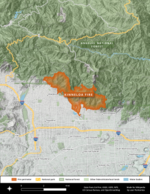
Henninger Flats
Angeles National ForestProtected areas of Los Angeles County, CaliforniaSan Gabriel MountainsUse mdy dates from April 2023

Henninger Flats is a small hanging basin 2,600 feet (792.5 m) above sea level in the San Gabriel Mountains in the Angeles National Forest. It was part of the Mount Wilson Toll Road. The trailhead to reach the flats is at the top end of Eaton Canyon in Pasadena, California.
Excerpt from the Wikipedia article Henninger Flats (License: CC BY-SA 3.0, Authors, Images).Henninger Flats
Mount Wilson Toll Road,
Geographical coordinates (GPS) Address Nearby Places Show on map
Geographical coordinates (GPS)
| Latitude | Longitude |
|---|---|
| N 34.1925 ° | E -118.087 ° |
Address
Mount Wilson Toll Road
Mount Wilson Toll Road
91023
California, United States
Open on Google Maps


