Groß Iser
Ethnic cleansing of GermansSudetes

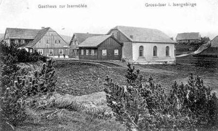
Górzystów was a village on Hala Izerska existing from the 17th century until 1945. Today the remains of the village can be found in Poland just by the Czech border (marked here by the Jizera river). The closest towns are Świeradów-Zdrój on the Polish side and Harrachov on the Czech side.
Excerpt from the Wikipedia article Groß Iser (License: CC BY-SA 3.0, Authors, Images).Groß Iser
Sina Droga, gmina Mirsk
Geographical coordinates (GPS) Address Nearby Places Show on map
Geographical coordinates (GPS)
| Latitude | Longitude |
|---|---|
| N 50.853055555556 ° | E 15.358333333333 ° |
Address
Sina Droga
gmina Mirsk
Lower Silesian Voivodeship, Poland
Open on Google Maps


