place

Westville Village Historic District

Federal architecture in ConnecticutGreek Revival architecture in ConnecticutHistoric districts in New Haven, ConnecticutHistoric districts on the National Register of Historic Places in ConnecticutNRHP infobox with nocat
National Register of Historic Places in New Haven, Connecticut
Westville4
Westville4

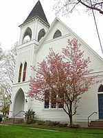
Westville Village Historic District is a historic district representing most of the commercial center of the Westville neighborhood of New Haven, Connecticut. This center developed in the 19th century as an industrial mill village distinct from the city center, and retains many architectural features of that period. The district was listed on the National Register of Historic Places in 2003, and its boundaries were increased slightly in 2006.

Excerpt from the Wikipedia article Westville Village Historic District (License: CC BY-SA 3.0, Authors, Images).

Westville Village Historic District
Walnut Tree Hill Road,

Geographical coordinates (GPS) Address Nearby Places
placeShow on map

Wikipedia: Westville Village Historic DistrictContinue reading on Wikipedia

Geographical coordinates (GPS)

Latitude Longitude
N 41.330555555556 ° E -73.172222222222 °
placeShow on map

Address

Walnut Tree Hill Road

Walnut Tree Hill Road
06484
United States
mapOpen on Google Maps

Westville4
Westville4
Share experience

Nearby Places

White Hills (Shelton)

White Hills is a section of the city of Shelton, Connecticut. It is one of the oldest parts of the city, with historical buildings dating to the early 18th century. It is the most rural part of Shelton, though much of it is now suburban. White Hills got its name for the higher altitude it has compared with the rest of Shelton. The rolling hills in the area were named White for several reasons: The snow melted slower in the spring, the visible lyme rock, and the wild dogwood blossoms. White Hills is bordered by Monroe to the north and west, the Housatonic River to the east, the "downtown" to the southeast, and Huntington to the southwest. Its road borders are roughly East Village Road to the east and north, Beardsley Road to the north, and Route 110 (Leavenworth and Shelton Roads) to the west and south. However, Maple Avenue (to the southwest) is considered part of Lower White Hills, but claimed by both Huntington and White Hills. The Lower White Hills Cemetery (1700) is on Maple Avenue, just west of Route 110. White Hills has a volunteer fire department, Shelton Fire Company 5. The fire company was formed in 1947 and the first truck was purchased in 1948, costing $7,000. Members signed personal notes to assure the payment of the new vehicle. They also held two-day country fairs to help in the payment for the new fire truck. Those two-day fairs were a tremendous amount of work. Some of the attractions were, animals and produce on exhibit, there was a baked goods table, white elephant table, snack bar, games of chance, raffles, square dancing, and many other attractions. The department has frequently won honors at local marching parades. White Hills has both a rural character and access to nearby shopping areas. The section of town is equidistant from Monroe center, Huntington center, and downtown Shelton. There is a recreational facility in the area called East Village Park, established in the early 1980s. Landmarks: Lincoln Spruce French's Corner

Huntington Center Historic District

The Huntington Center Historic District is a historic district in the city of Shelton, Connecticut. The district encompasses the original colonial settlement of Shelton, which was first known as Huntington. It is a linear district about 0.75 miles (1.21 km) in length, centered on the Huntington Green and Cemetery, and extending north along Church Street and south along Huntington Street. The district is predominantly residential, although it has two churches. The green was laid out in 1717, and many of the district's historic buildings were built over the next 150 years. The district's oldest building is a house with an estimated construction date of 1710. The district was listed on the National Register of Historic Places in 2000.The area that is now Shelton was settled by English colonists in the 17th century as part of Stratford. In 1717 a Congregationalist parish was established, and in 1789 the town of Huntington was incorporated, including what is now neighboring Monroe. The site of the early parish became the center of the new town. In addition to its civic function, the area also developed some industry, powered by the waters of the Farmill River and Means Brook. In the second half of the 19th century, the community's industrial and civic focus shifted to the Housatonic River (its eastern border), and it was renamed Shelton in 1919 in honor of Edward Shelton, one of its major industrialists. Shelton's likely ancestral home still stands in Huntington Center.