Port Royal Island

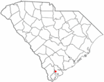
Port Royal Island (historically Port Royal) is an island located in Beaufort County, South Carolina. It is considered one of the Sea Islands in the Lowcountry region and is the most populous island in northern Beaufort County, containing most of the incorporated areas of Beaufort, Port Royal, and other unincorporated communities. The island also contains the Marine Corps Air Station Beaufort and Naval Hospital Beaufort military installations. The island takes its name from the Port Royal Sound, a historically significant harbor during colonial settlement in the 16th, 17th, and 18th centuries. From the time of its European discovery to the late 19th century, the name "Port Royal" typically applied to Port Royal Island as a whole and the surrounding waterways. In the early 21st century, the term Port Royal is understood to apply to the incorporated town of Port Royal.
Excerpt from the Wikipedia article Port Royal Island (License: CC BY-SA 3.0, Authors, Images).Port Royal Island
Rivers Hill Road,
Geographical coordinates (GPS) Address Nearby Places Show on map
 Continue reading on Wikipedia
 Geographical coordinates (GPS)
| Latitude | Longitude |
|---|---|
| N 32.435555555556 ° | E -80.738611111111 ° |
Address
Rivers Hill Road
Rivers Hill Road
29906
South Carolina, United States
Open on Google Maps