Reporoa
Populated places in WaikatoRotorua Lakes DistrictUse New Zealand English from January 2023

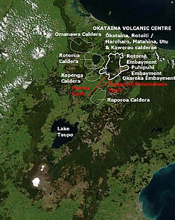
Reporoa is a rural community in Rotorua Lakes within the Waikato region of New Zealand's North Island. It is located within the Reporoa Caldera, a caldera in the Taupō Volcanic Zone containing the Deer Hill, Kairuru and Pukekahu rhyolitic lava domes and the active Reporoa geothermal field. Several hydrothermal explosions have occurred in the area, with a large one being recorded in 1948, and another large one occurring in a cow paddock in April 2005. The New Zealand Ministry for Culture and Heritage gives a translation of "long swamp" for Reporoa.
Excerpt from the Wikipedia article Reporoa (License: CC BY-SA 3.0, Authors, Images).Reporoa
Settlers Road,
Geographical coordinates (GPS) Address Nearby Places Show on map
 Continue reading on Wikipedia
 Geographical coordinates (GPS)
| Latitude | Longitude |
|---|---|
| N -38.436003 ° | E 176.340785 ° |
Address
Settlers Road 606
3083
Waikato, New Zealand
Open on Google Maps