DAS Building bombing
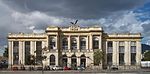
The DAS Building bombing was a truck bomb attack in Bogotá, Colombia, at 7:30 am on December 6, 1989, targeting the Administrative Department of Security (DAS) headquarters. A truck parked near the building exploded, killing 57 people instantly and injuring 2,248. The bomb blast, an estimated 500 kg of dynamite, destroyed 14 city blocks and destroyed more than 300 commercial properties. The last victim of the bombing died on April 27 1990. It was the deadliest car bomb attack in Latin America before being succeeded by the AMIA bombing 5 years later. It is widely believed that the Medellín Cartel was responsible for the attack, in an attempt to assassinate DAS director Miguel Maza Márquez, who escaped unharmed. The same group was believed to be behind the bombing of Avianca Flight 203 9 days before.The DAS building bombing was the last in the long series of attacks that targeted Colombian politicians, officials, and journalists in 1989, which started with the January 18 killing of 12 judicial officials in Simacota.
Excerpt from the Wikipedia article DAS Building bombing (License: CC BY-SA 3.0, Authors).DAS Building bombing
Avenida Carrera 27, Bogota Localidad Los Mártires
Geographical coordinates (GPS) Address Nearby Places Show on map
 Continue reading on Wikipedia
 Geographical coordinates (GPS)
| Latitude | Longitude |
|---|---|
| N 4.615231 ° | E -74.086708 ° |
Address
Avenida Carrera 27 (Avenida General Santander)
Avenida Carrera 27
111411 Bogota, Localidad Los Mártires
Colombia
Open on Google Maps