place

Mount Parker (Hong Kong)

Eastern District, Hong KongHong Kong Island geography stubsHong Kong mountain stubsMountains, peaks and hills of Hong KongQuarry Bay
Southern District, Hong KongTai Tam
Tai Koo Shing 2008
Tai Koo Shing 2008

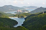
Mount Parker is the second-highest peak (532 metres (1,745 ft)) on Hong Kong Island, after Victoria Peak (552 m (1,811 ft)). It is the 40th highest peak of the territory of Hong Kong.

Excerpt from the Wikipedia article Mount Parker (Hong Kong) (License: CC BY-SA 3.0, Authors, Images).

Mount Parker (Hong Kong)
Mount Parker Road, Hong Kong Island Quarry Bay (Eastern District)

Geographical coordinates (GPS) Address Nearby Places
placeShow on map

Wikipedia: Mount Parker (Hong Kong)Continue reading on Wikipedia

Geographical coordinates (GPS)

Latitude Longitude
N 22.265472222222 ° E 114.21913888889 °
placeShow on map

Address

柏架山道 Mount Parker Road

Mount Parker Road
Hong Kong Island, Quarry Bay (Eastern District)
Hong Kong, China
mapOpen on Google Maps

Tai Koo Shing 2008
Tai Koo Shing 2008
Share experience

Nearby Places

Tai Tam Reservoirs
Tai Tam Reservoirs

The Tai Tam Reservoirs, also known as Tai Tam Reservoir Group, is a group of reservoirs located in the Tai Tam Country Park in the eastern part of Hong Kong Island in Hong Kong. The reservoirs consist of: Tai Tam Upper Reservoir (大潭上水塘), 22.260°N 114.210°E / 22.260; 114.210 Tai Tam Byewash Reservoir (大潭副水塘), Tai Tam Intermediate Reservoir (大潭中水塘) 22.246°N 114.210°E / 22.246; 114.210 and Tai Tam Tuk Reservoir (大潭篤水塘) 22.243°N 114.220°E / 22.243; 114.220.The upper and byewash reservoirs are jointly known as Tai Tam Reservoir (大潭水塘). The planning of the reservoirs is known as Tai Tam Scheme which was started early in 1872 and was shelved in 1874 because of economic depression. The scheme was continued later in 1882 and virtually completed in 1888. Yet again, the supply was proved insufficient and the building of the Tai Tam Tuk dam began in 1912. The four reservoirs have a total storage capacity of 6.2 million cubic metres. The reservoirs are surrounded by Mount Butler (畢拿山), Jardine's Lookout, Violet Hill and Mount Parker, with an extraordinary environment of peace and quiet. The reservoirs are managed by Water Supplies Department of Hong Kong Government. In September 2009, the Tai Tam Waterworks Heritage Trail was opened, touring the architectural landmarks of the reservoir system. Placards in describe the features, giving insights into the work involved in the construction of what the source of most of Hong Kong Island's fresh water supply. A restricted road, Tai Tam Reservoir Road, links reservoirs from Wong Nai Chung Gap to Tai Tam.