Warner Center, Los Angeles

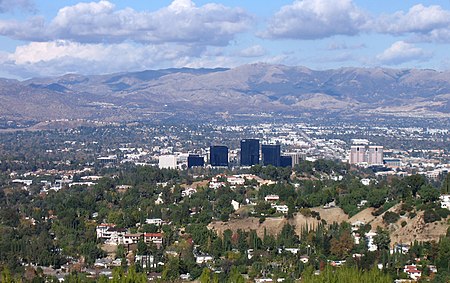
Warner Center is a master-planned neighborhood and business district development in the Canoga Park and Woodland Hills neighborhoods of the San Fernando Valley in Los Angeles, California.Warner Center, which began as a master-planned area, is designated as a Regional Center within the City's Canoga Park-West Hills-Winnetka-Woodland Hills Community Plan. Historically, Warner Center is generally bounded by Vanowen Street to the north, the Ventura Freeway to the south, De Soto Avenue to the east, and Topanga Canyon Boulevard on the west. The Warner Center 2035 Plan (adopted in December 2013) added the area between Vanowen and the LA River to the plan area, which comprises approximately 1,100 acres or 1.7 square miles.The area was originally planned to relieve traffic to and from downtown Los Angeles, as well as generate jobs in the San Fernando Valley. It was first envisioned in the late 1960s.
Excerpt from the Wikipedia article Warner Center, Los Angeles (License: CC BY-SA 3.0, Authors, Images).Warner Center, Los Angeles
Oxnard Street, Los Angeles Warner Center
Geographical coordinates (GPS) Address Nearby Places Show on map
Geographical coordinates (GPS)
| Latitude | Longitude |
|---|---|
| N 34.179 ° | E -118.601 ° |
Address
Warner Center Tower III
Oxnard Street 21650
91367 Los Angeles, Warner Center
California, United States
Open on Google Maps


