place

Rialto, California

1911 establishments in CaliforniaChicano and Mexican neighborhoods in CaliforniaCities in San Bernardino County, CaliforniaIncorporated cities and towns in CaliforniaPopulated places established in 1911
Populated places in San Bernardino County, CaliforniaRialto, CaliforniaUse mdy dates from September 2014
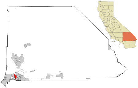
San Bernardino County California Incorporated and Unincorporated areas Rialto Highlighted

Rialto is a city in San Bernardino County, California, United States, 56 miles east of Los Angeles, near the Cajon Pass, Interstate 15, Interstate 10, State Route 210 and Metrolink routes. Its population was 104,026 as of the 2020 Census, up from 99,171 at the 2010 Census. Its population and economic activity have grown rapidly in recent years due to the building of major distribution centers in the region. The U.S. Army Rialto Ammunition Storage point was used during World War II to support operations in the Pacific theater. Rialto is home to major regional distribution centers: Staples Inc., which serves stores across the entire West Coast of the United States, Amazon, Under Armour, Medline Industries, Niagara Bottling, Monster Energy and Target in the northern region of the city, in the Las Colinas community. One of the United States' largest fireworks companies, Pyro Spectaculars, is also headquartered in Rialto.

Excerpt from the Wikipedia article Rialto, California (License: CC BY-SA 3.0, Authors, Images).

Rialto, California
North Yucca Avenue,

Geographical coordinates (GPS) Address Nearby Places
placeShow on map

Wikipedia: Rialto, CaliforniaContinue reading on Wikipedia

Geographical coordinates (GPS)

Latitude Longitude
N 34.111388888889 ° E -117.3825 °
placeShow on map

Address

North Yucca Avenue 659
92376
California, United States
mapOpen on Google Maps

San Bernardino County California Incorporated and Unincorporated areas Rialto Highlighted
Share experience

Nearby Places

Rialto Municipal Airport

Rialto Municipal Airport (FAA LID: L67), originally Miro Field, was a general aviation airport three miles (5 km) northwest of Rialto, in San Bernardino County, California, United States. It was used by private aircraft; no airlines flew into this airport. It was about 12 miles northeast of Ontario International Airport and ten miles west of San Bernardino International Airport. The airport did not have a control tower and averaged 82 operations a day. An FBO with a flight school and a separate helicopter flight school operated at the airport. There were several aviation related businesses. Warbirds West Air Museum is relocating its warbird collection to the big hangar at the center of the field. The airport cafe is attached to the WWAM hangar. There was an air ambulance business in the southeast part of the airport. Despite its size compared to nearby airfields (Upland Cable Airport, Corona Municipal Airport, El Monte Municipal Airport, Redlands Municipal Airport and Hemet-Ryan Airport), Rialto was a relatively quiet airport. This led the city of Rialto to approve the closing of the airport by 2009/2010 for redevelopment, driven by real estate developers. The airport was expected to close by January or February 2015, once the San Bernardino County Sheriff's Department Aviation Division relocated to the San Bernardino International Airport. Development of Renaissance Marketplace was planned to begin as soon as the airport closes and the runways are removed. On September 18, 2014, the airport officially closed to air traffic; all runways are marked with yellow Xs.