place

Bolinas, California

Artist coloniesBolinas, CaliforniaCensus-designated places in CaliforniaCensus-designated places in Marin County, CaliforniaPopulated coastal places in California
Unincorporated communities in CaliforniaUse mdy dates from July 2023West Marin
Bolinas, CA 3422
Bolinas, CA 3422

Bolinas is an unincorporated coastal community and census-designated place in Marin County, California, United States. As of the 2020 census it had a population of 1,483. It is located on the California coast, approximately 13 miles (21 km) (straight line distance) northwest of San Francisco, and 27 miles (43 km) by road. The community is known for its reclusive residents. It is only accessible via unmarked roads; any road sign along State Route 1 that points the way into town has been torn down by local residents, to the point where county officials offered a ballot measure to which the voters responded by stating a preference for no more signs.

Excerpt from the Wikipedia article Bolinas, California (License: CC BY-SA 3.0, Authors, Images).

Bolinas, California
Wharf Road,

Geographical coordinates (GPS) Address Phone number Nearby Places
placeShow on map

Wikipedia: Bolinas, CaliforniaContinue reading on Wikipedia

Geographical coordinates (GPS)

Latitude Longitude
N 37.909444444444 ° E -122.68638888889 °
placeShow on map

Address

Bo-gas BCLT housing

Wharf Road 6
94924
California, United States
mapOpen on Google Maps

Phone number

call4158688880

Bolinas, CA 3422
Bolinas, CA 3422
Share experience

Nearby Places

Bolinas Lagoon
Bolinas Lagoon

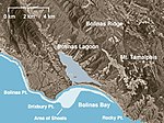
Bolinas Lagoon is a tidal estuary, approximately 1,100 acres (4.5 km2) in area, located in the West Marin region of Marin County, California, United States, adjacent to the town of Bolinas. It is a part of the Greater Farallones National Marine Sanctuary. In 1974, Aubrey Neasham and William Pritchard wrote in support of Bolinas Lagoon as Drake's New Albion landing site.The lagoon is a back bay of Bolinas Bay on the Pacific coast approximately 15 mi (25 km) northwest of San Francisco. The trough in which the lagoon sits was formed by the San Andreas Fault, which runs directly through it. The lagoon is separated from the main bay by a small spit of land, known as Stinson Beach, and the sand bar that encloses this lagoon is full of beachgoers and surfers on hot days, seeking to escape the heat and the urban Bay Area. State Route 1, the Shoreline Highway, runs along the eastern edge of the lagoon. Bolinas Lagoon is on the list of wetlands of international importance as defined by the Ramsar Convention for the conservation and sustainable utilization of wetlands. Portions of the lagoon are included in Marin County's Bolinas Lagoon Open Space Preserve, and the western shore is part of the Golden Gate National Recreation Area. The lagoon has a 16.7-square-mile (43 km2) watershed; streams and canyons feeding into it include Audubon Canyon, McKinnan Gulch, Morses Gulch, Picher Canyon, Pike County Gulch, Stinson Gulch, Volunteer Canyon, and Wilkins Gulch. Kent Island is located in the lagoon. Duxbury Reef State Marine Conservation Area lies offshore from Bolinas. Like an underwater park, this protected marine area helps conserve ocean wildlife and marine ecosystems.

Audubon Canyon Ranch

Audubon Canyon Ranch (ACR) is a 501(c)(3) not-for-profit environmental conservation and education organization headquartered in Stinson Beach, Marin County, California, on the eastern shore of Bolinas Lagoon. The lands upon which ACR operates are within the ancestral territories of the Coast Miwok, Southern Pomo and Wappo peoples. ACR recognizes that Indigenous communities are very much alive today and striving to protect and maintain relationships with cultural and natural resources on ACR lands; they acknowledge that Indigenous lands are occupied by them and others. Audubon Canyon Ranch was founded in 1962 to save a major heronry and block commercial development of Bolinas Lagoon in western Marin County, leading the way for the protection of Tomales Bay to the north. Today, Audubon Canyon Ranch stewards a system of nature preserves totaling 5,000 acres (2,000 ha) across 26 properties in Marin County and Sonoma County and conducts conservation science that in turn informs its education programs and directs its work on some of the region's most challenging environmental issues. ACR's conservation science program has monitored the North Bay region nesting successes of herons and egrets for over 40 years, collected long-term data sets on wintering shorebird and waterbird populations on Tomales Bay for over 30 years, and is using GPS to track the movements of individual mountain lions in the Sonoma Valley and Great Egrets and Long-billed Curlews on the coast. ACR's experiential nature education program, which turned 50 in 2020, has connected more than 300,000 Bay Area children and adults to the wonders of nature, cultivating environmental literacy and a conservation ethic. ACR's Fire Forward program, founded in 2017, is advancing our community's ability to use "good fire" to reduce risk and build ecosystem resilience against climate-driven wildfire events. ACR also stewards cultural treasures, including the literary legacy of American author M.F.K. Fisher at her last house at Bouverie Preserve.