place

Fort Vasquez

1835 establishments in unorganized territory of the United StatesFormer populated places in ColoradoFormer populated places in Weld County, ColoradoForts in ColoradoForts on the National Register of Historic Places in Colorado
Fur tradeGeography of Weld County, ColoradoHistory ColoradoHistory museums in ColoradoMexican–American War fortsMuseums in Weld County, ColoradoNational Register of Historic Places in Weld County, ColoradoTrading posts in Colorado
Insidefrvasquez2
Insidefrvasquez2

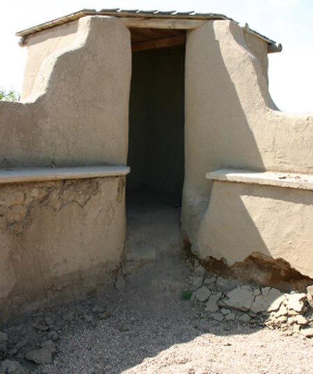
Fort Vasquez is a former fur trading post 35 miles (56 km) northeast of Denver, Colorado, United States, founded by Louis Vasquez and Andrew Sublette in 1835. Restored by the Works Progress Administration in the 1930s, it now lies in a rather incongruous position as U.S. Route 85 splits to run either side of the building. History Colorado (then the Colorado Historical Society) took possession of the property in 1958 and runs it as a museum to display exhibits of the fur-trade era.

Excerpt from the Wikipedia article Fort Vasquez (License: CC BY-SA 3.0, Authors, Images).

Fort Vasquez
United States Highway 85,

Geographical coordinates (GPS) Address Nearby Places
placeShow on map

Wikipedia: Fort VasquezContinue reading on Wikipedia

Geographical coordinates (GPS)

Latitude Longitude
N 40.194444444444 ° E -104.82027777778 °
placeShow on map

Address

United States Highway 85

United States Highway 85
80620
Colorado, United States
mapOpen on Google Maps

Insidefrvasquez2
Insidefrvasquez2
Share experience

Nearby Places

Fort Saint Vrain
Fort Saint Vrain

Fort Saint Vrain was an 1837 fur trading post built by the Bent, St. Vrain Company, and located at the confluence of Saint Vrain Creek and the South Platte River, about 20 miles (32 km) east of the Rocky Mountains in the unorganized territory of the United States, in present-day Weld County, Colorado. A historical marker notes the place where Old Fort St. Vrain once stood, today at the end of Weld County Road 40, located about seven miles north of Fort Vasquez, Colorado. Among those who helped to establish the fort was Ceran St. Vrain, after whom it was named. William Clark, governor of the territory, granted the Bent, St. Vrain Co. a license to trade on November 8, 1836. Like neighboring forts, the structure was built as a two-story adobe structure whose walls encased an interior courtyard. It accommodated trade with Native American tribes and mountain men engaged in fur trapping. It resembled the adobe building and plaza reconstructed at Fort Vasquez and Bent's Old Fort. Marcellin St. Vrain, Ceran's brother, managed the trading post. He employed such notable people as James Beckwourth, a mountain man, and Jean Baptiste Charbonneau, who was born to Sacajewea during the 1804-1806 Lewis and Clark Expedition. She accompanied the expedition with her husband, trader & trapper Toussaint Charbonneau as well as newborn Jean Baptiste, while filling the crucial role of translator to the Shoshone Indian tribe. After the Taos Revolt in 1847, the St. Vrain brothers both returned to St. Louis. After Ceran St. Vrain sold his shares of the Bent, St. Vrain Co., William Bent became sole proprietor by 1849. Bent moved to Fort St. Vrain temporarily before building a new Fort Bent in the Big Timbers area.

St. Vrain Creek
St. Vrain Creek

St. Vrain Creek (often known locally as the St. Vrain River) is a tributary of the South Platte River, approximately 32.2 miles (51.8 km) long, in north central Colorado in the United States. It drains part of the foothills north of Boulder and the Colorado Piedmont area in the vicinity of Longmont. The creek is formed by the confluence of North and South St. Vrain creeks at Lyons. The creek rises in several branches in the foothills of the Front Range northwest of Boulder. Middle St. Vrain Creek rises along the continental divide, west of St. Vrain Mountain. It descends in canyon to flow along State Highway 7 and past Raymond. It joins the shorter South St. Vrain Creek about two miles below Raymond. Parts of the South St. Vrain Creek form a five-mile (8.0 km) Class 5+ kayak run during normal flows. North St. Vrain Creek rises northeast of St. Vrain Mountain near Mount Alice and Chiefs Head Peak, and descends in a remote canyon to the east along U.S. Highway 36. The two branches join at Lyons, at the mouth of the canyon. East of Lyons, the combined stream flows southeast through farmland and ranch country, passing south of Hygiene and entering Longmont. It passes through the south side of Longmont where it is rimmed by a greenway trail and several parks. East of Longmont it flows generally northeast, meandering through a wide river bottom in ranch country and passing under Interstate 25 south of the intersection with State Highway 66. It joins the South Platte from the west just upstream from the ruins of Fort St. Vrain and approximately four miles (6.4 km) northwest of Platteville. St. Vrain Creek is joined by Left Hand Creek south of Longmont and Boulder Creek east of Longmont. The stream was named after Ceran St. Vrain, a pioneer trader.