Hartpury
Civil parishes in GloucestershireForest of DeanGloucestershire geography stubsUse British English from January 2015Villages in Gloucestershire

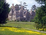
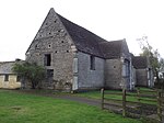
Hartpury is a civil parish in Gloucestershire, England. It has an area of about 3,500 acres (1,400 ha), about 270 homes and a population of about 700 people, increasing to 1,642 at the 2011 census. The village is about 5 miles (8 km) north of Gloucester. Geographically the parish is in Leadon Vale; administratively it is in the Forest of Dean. The Hartpury University and Hartpury College campus is based in the village.
Excerpt from the Wikipedia article Hartpury (License: CC BY-SA 3.0, Authors, Images).Hartpury
Corsend Road, Forest of Dean Hartpury
Geographical coordinates (GPS) Address Nearby Places Show on map
Geographical coordinates (GPS)
| Latitude | Longitude |
|---|---|
| N 51.92765 ° | E -2.29743 ° |
Address
Corsend Road
Corsend Road
GL19 3BP Forest of Dean, Hartpury
England, United Kingdom
Open on Google Maps


