St. Pauli Piers

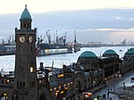
The St. Pauli Piers (German: St. Pauli Landungsbrücken, often only referred to as Landungsbrücken; German pronunciation: [ˈlandʊŋsˌbʁʏkŋ̍]), are the largest landing place in the Port of Hamburg, Germany, and also one of Hamburg's major tourist attractions. Other English language translations include St. Pauli Landing Stages or St. Pauli Landing Bridges. The piers are located in the St. Pauli area of Hamburg, between the lower harbour and the Fischmarkt (Fish Market), on the banks of the Elbe river. The Landungsbrücken today form a central transportation hub, with S-Bahn, U-Bahn and ferry stations, and are also a major tourist magnet with numerous restaurants and departure points for harbour pleasure boats. There is an entrance to the Old Elbe tunnel at the western end of the Landungsbrücken. The eastern end of the building complex is marked by the Pegelturm (water level tower). Halfway up the tower, there is a water level indicator built into the wall, which indicates the current stage of the tides.
Excerpt from the Wikipedia article St. Pauli Piers (License: CC BY-SA 3.0, Authors, Images).St. Pauli Piers
Bei den St. Pauli-Landungsbrücken, Hamburg St. Pauli
Geographical coordinates (GPS) Address Nearby Places Show on map
Geographical coordinates (GPS)
| Latitude | Longitude |
|---|---|
| N 53.546111111111 ° | E 9.9666666666667 ° |
Address
Bei den St. Pauli-Landungsbrücken
Bei den St. Pauli-Landungsbrücken
20359 Hamburg, St. Pauli
Germany
Open on Google Maps


