place

Dunning, Perth and Kinross

Use British English from January 2018Villages in Perth and Kinross
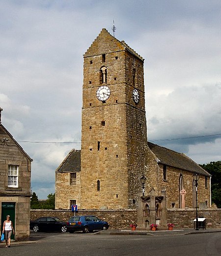
St Serf's Church, Dunning

Dunning is a small village in Perth and Kinross in Scotland with a population of about 1,000. The village centres around the 12th–13th century former parish church of St. Serf, where the Dupplin Cross is displayed (Historic Scotland; open in summer without entrance charge). It is in Strathearn, north of the Ochil Hills. It is just south of the A9, between Auchterarder and Perth.

Excerpt from the Wikipedia article Dunning, Perth and Kinross (License: CC BY-SA 3.0, Authors, Images).

Dunning, Perth and Kinross
The Glebe,

Geographical coordinates (GPS) Address Nearby Places
placeShow on map

Wikipedia: Dunning, Perth and KinrossContinue reading on Wikipedia

Geographical coordinates (GPS)

Latitude Longitude
N 56.3118 ° E -3.58896 °
placeShow on map

Address

The Glebe

The Glebe
PH2 0RF
Scotland, United Kingdom
mapOpen on Google Maps

St Serf's Church, Dunning
Share experience

Nearby Places

Dupplin Cross
Dupplin Cross

The Dupplin Cross is a carved, monumental Pictish stone, which dates from around 800 AD. It was first recorded by Thomas Pennant in 1769, on a hillside in Strathearn, a little to the north of (and on the opposite bank of the River Earn from) Forteviot and Dunning. In 2002 it was placed in the care of Historic Scotland, and was placed for preservation under the 11th/12th-century tower of St Serf's Church, Dunning. The Dupplin Cross is a high cross, that is a free-standing stone cross. While relatively common in Ireland, Northumbria and in Dál Riata, such crosses are rare survivals in the lands of the Picts, though fragments of shattered crosses (probably cast down during the 16th-century Reformation) show that a number once existed. In the 18th century a second cross, the Cross of Dronachy, was recorded as having stood on the lands of Invermay, south of Forteviot and also overlooking Forteviot, but having fallen and broken. The cross base survives in situ, but the records do not provide details of its exact form. The cross is carved from Old Red Sandstone, the cross stands about 2.5 metres tall, 1 metre broad over the arms of the cross. It is carved with various scenes, religious, martial and traditional Pictish animal carvings. The cross contains a partially legible inscription, of which only the name CUSTANTIN FILIUS FIRCUS can be read. This name is taken as the Latin form of the early 9th-century Pictish king's Gaelic name Caustantín son of Fergus (fl. 793–820). Since the inscription implies that the cross was carved either during, or shortly after, the reign of Caustantín, it is particularly important as giving a fixed point in the chronology of Pictish sculpture. It also indicates that Gaelic was spoken at the time as it uses the Gaelic personal name of his father in Latin. Other carved themes on the cross include a rider with an oversized head and ponytail showing him to be a man of authority. On the obverse a man fights bears with his bare hands. The sides include a man (probably David) playing a harp, and hunting dogs.
Glendevon Castle

Glendevon Castle is a collection of conjoined structures dating from the 15th century. The property is now (2022) semi-derelict. It lies on a private road in a wooded area north of the A823 between Glendevon Village and Gleneagles. It is not visible from the main road. The oldest section is a Z-plan structure dating from the early 15th century. It stands on high ground, and before the planting of the surrounding trees, it held a wide view over the surrounding valley. From around 1650 it had diagonally opposed square towers to both south-west and north-east, but only the south-west tower is intact at its four-storey height, with the remainder being reduced. A smaller circular tower (dating from around 1700) stands on its west side.In 1452, at the time of his murder, the castle belonged to William Douglas, 8th Earl of Douglas. In the 16th century the castle was acquired by the Crauford family. The Rutherfords acquired the building in the 18th century by which time it had been extended on its north side by low scale vernacular buildings and was primarily in farm use. Further farm structures were built to the east in the 20th century.The building was listed category B in 1987. The Historic Scotland description surmises that the structure was greatly reduced in size in 1766, as a date-stone bears this date.From 1966 to around 1987 the building held a "wayside hostelry" known as the Dungeon Bar in its vaulted basement. The bar was partly linked to a caravan park on the low-lying ground to its west.The property is said to be haunted by at least three ghosts.