place

Moulsford Railway Bridge
Arch bridges in the United KingdomBridges across the River ThamesBridges by Isambard Kingdom BrunelBridges completed in 1839Grade II* listed buildings in Oxfordshire
Grade II* listed railway bridges and viaductsGreat Western Main LineHistory of BerkshireRailway bridges in OxfordshireSkew bridgesUse British English from December 2017
MoulsfordRlyBr01
MoulsfordRlyBr01

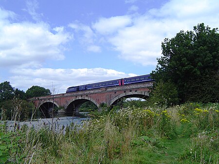
Moulsford Railway Bridge, also known locally as "Four Arches" bridge, is a pair of parallel bridges located a little to the north of Moulsford and South Stoke in Oxfordshire, UK. It carries the Great Western Main Line from Paddington, London to Wales and the West across the River Thames. The bridge lies between the stations at Goring & Streatley and Cholsey, and crosses the Thames at an oblique angle on the reach between Cleeve Lock and Benson Lock. The original Moulsford Railway Bridge was built between 1838 and 1840, having been designed by Isambard Kingdom Brunel for the main trunk route of the Great Western Railway. Built to carry a pair of broad gauge tracks across the Thames, it consists of four low semi-elliptical arches spanning the Thames at a considerably skewed angle of 60 degrees. During the 1890s, a second bridge was built immediately parallel to the original structure, enabling the railway to be expanded to a quadruple track configuration. The bridge was subsequently recognised as a Grade II* listed structure. During the 2010s, the lines across the structure were electrified

Excerpt from the Wikipedia article Moulsford Railway Bridge (License: CC BY-SA 3.0, Authors, Images).

Moulsford Railway Bridge
Waterloo Close, South Oxfordshire

Geographical coordinates (GPS) Address External links Nearby Places
placeShow on map

Wikipedia: Moulsford Railway BridgeContinue reading on Wikipedia

Geographical coordinates (GPS)

Latitude Longitude
N 51.558055555556 ° E -1.1425 °
placeShow on map

Address

Moulsford Railway Bridge (1839)

Waterloo Close
OX10 9LU South Oxfordshire
England, United Kingdom
mapOpen on Google Maps

linkWikiData (Q13528022)
linkOpenStreetMap (585146502)

MoulsfordRlyBr01
MoulsfordRlyBr01
Share experience

Nearby Places

Winterbrook

Winterbrook is a small settlement in the English county of Oxfordshire, which adjoins the south end of Wallingford and sits on the west bank of the Thames. It is separated from Wallingford by Bradford's Brook. In 1974 it was transferred from Berkshire. Although having been part of the adjacent parish of Cholsey for centuries, its proximity to Wallingford resulted in its being absorbed into that town for administrative purposes in 2015. This change was effected despite the strenuous and long-term objections of the residents. It is now part of the Wallingford ward of South Oxfordshire District Council. It remains in the Church of England parish of St Mary the Virgin, North Stoke. Winterbrook appears in records from the time of King Henry III. It is connected to the east bank by Winterbrook Bridge. The common lands in Winterbrook were enclosed in 1851. Winterbrook House is a Grade II listed 17th-century house. Its most famous resident was the novelist, Agatha Christie, who lived at Winterbrook House and died there in 1976. Winterbrook Lodge and Winterbrook Close are both Grade II listed early 19th-century houses. Other major buildings include the Waterside Court Care Home and the Winterbrook Nursing Home. As of 2009, Winterbrook residents were campaigning against its possible selection as the preferred option for 850 new houses as part of the South Oxfordshire Core Strategy as well as a preemptive planning application by Wates Homes Ltd (part of Wates Group) for 106 dwellings. Planning permission was refused.