Carbondale, Ohio

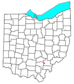
Carbondale is an unincorporated community in northwestern Waterloo Township, Athens County, Ohio, United States. It has a post office with the ZIP code 45717. It is located a short distance north of State Route 56. The town is located on Carbondale Creek, which flows into Hewett Fork just below the town. Hewett Fork is a tributary of Raccoon Creek, which is a tributary of the Ohio River. The name refers to the once-abundant coal resources in the hills and valleys surrounding the community. The first coal mines in Carbondale opened in 1867, soon after the railroad was completed to that point. The area was extensively mined, with all mines closing years ago. The community is closely hemmed in by the Zaleski State Forest, including the Enderlin Forest just west of town, which includes one of the earliest large-scale white pine plantations in the state, and features the state's champion white pine tree.
Excerpt from the Wikipedia article Carbondale, Ohio (License: CC BY-SA 3.0, Authors, Images).Carbondale, Ohio
Carbondale Road,
Geographical coordinates (GPS) Address Nearby Places Show on map
Geographical coordinates (GPS)
| Latitude | Longitude |
|---|---|
| N 39.377777777778 ° | E -82.271111111111 ° |
Address
Carbondale Road 11598
45764
Ohio, United States
Open on Google Maps


