place

Caer Gybi (fort)

Archaeological sites in AngleseyCadwHolyheadRoman fortifications in AngleseyRoman legionary fortresses in Wales
Scheduled monuments in AngleseyUse British English from January 2017Welsh building and structure stubs
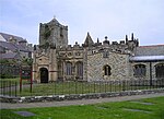
Roman Wall around the site of St Cybi's Church geograph.org.uk 1414149

Caer Gybi was a small fortlet in Roman Wales in the Roman province of Britannia Superior. Its name in Latin is unknown. Today it stands at the centre of Holyhead in the Welsh county of Anglesey. Holyhead is named Caergybi in Welsh, after the fort. The fort is one of Europe's only three-walled Roman forts. The fourth side fronted the sea and was probably the site of a quay. Its date is unknown, but it is generally thought to be part of a late-4th-century scheme, associated with Segontium, which was used to defend the west coast against Irish sea-raiders. The Romans also built a watch tower, within Mynydd y Twr on the top of Holyhead Mountain, which was almost certainly used as the fort's look-out point. Both were possibly abandoned around 393, when the troops were sent to respond to the revolt of Eugenius of Gaul. In the 6th century, the old fort was given to Saint Cybi, who founded a monastery there. The Church of St Cybi still stands on the site today, with a small detached chapel (Eglwys y Bedd) that reputedly stands over Cybi's grave.

Excerpt from the Wikipedia article Caer Gybi (fort) (License: CC BY-SA 3.0, Authors, Images).

Caer Gybi (fort)
Victoria Road,

Geographical coordinates (GPS) Address Nearby Places
placeShow on map

Wikipedia: Caer Gybi (fort)Continue reading on Wikipedia

Geographical coordinates (GPS)

Latitude Longitude
N 53.3118 ° E -4.6328 °
placeShow on map

Address

Victoria Road
LL65 1DD , Porth-y-Felin
Wales, United Kingdom
mapOpen on Google Maps

Roman Wall around the site of St Cybi's Church geograph.org.uk 1414149
Share experience

Nearby Places

Holyhead Market Hall

Holyhead Market Hall, located in Holyhead, Anglesey, Wales, is a Grade II listed building built in 1855. It was commissioned by the local landowner and politician William Owen Stanley and built by J. Edwards Thomas. As well as housing the town's market it has historically been used as a law court, a military barracks, a mechanics' library and a boxing/wrestling venue. Located on the site of the old market cross and accessed from Stanley Street, the town's main throughfare, it was changed and improved in 1906. It is a two-storey building measuring 1,732 square metres and is built of local green shaley rubble with buff sandstone dressings and slate roofing. After 145 years of use the hall temporarily closed its doors, then became a furniture store and, fittingly, a grocery store. The building was listed in 1992, "for its importance to Holyhead and as a prominent mid C19 town centre building with a well preserved facade."After it stood empty for 15 years, becoming one of the most "dilapidated civic buildings in Wales," the Isle of Anglesey County Council gained control of the building via a compulsory purchase order. The council then restored it with funding from the National Assembly for Wales and the National Lottery Heritage Fund. Opening in September 2019, the building now houses the town's library as well as meeting rooms available to rent by local interest groups and businesses. In 2020 the project won a Royal Institution of Chartered Surveyors Social Impact Award, with judges from the Institution stating: "The revitalising of Holyhead Market Hall has not only conserved a landmark building in Holyhead, but has also provided a much need[ed] social facility with a diverse range of activities. The remodelling of the building in a way that also retains and presents the archaeology and historic features of the building is impressive."