place

Huntington Township, Brown County, Ohio

Townships in Brown County, OhioTownships in OhioUse mdy dates from July 2023
Aberdeen Mound from a distance

Huntington Township is one of the sixteen townships of Brown County, Ohio, United States. The 2020 census found 2,478 people in the township.

Excerpt from the Wikipedia article Huntington Township, Brown County, Ohio (License: CC BY-SA 3.0, Authors, Images).

Huntington Township, Brown County, Ohio

Geographical coordinates (GPS) Address Nearby Places
placeShow on map

Wikipedia: Huntington Township, Brown County, OhioContinue reading on Wikipedia

Geographical coordinates (GPS)

Latitude Longitude
N 38.689166666667 ° E -83.758333333333 °
placeShow on map

Address


45101
Ohio, United States
mapOpen on Google Maps

Aberdeen Mound from a distance
Share experience

Nearby Places

Pogue House
Pogue House

The Pogue House is a historic house in Maysville, Kentucky. It was built in 1845 on a fifteen-acre lot for industrialist Michael Ryan. The property was named "Riverside" by Ryan since it sits on a hillside with a sweeping ten-mile (16 km) vista of the Ohio River. The property was subdivided in 1955 and the historic portion currently comprises three acres. The Greek Revival floor plan includes three stories of living space two rooms wide and two rooms deep with a center hall plus a partial basement. The brick structure with an ashlar limestone foundation was one of the largest Kentucky residences in 1845 with 4,850 square feet (451 m2) of living space.The residence was purchased by Henry E. Pogue II and significantly upgraded circa 1890. Improvements included the installation of three sets of pocket doors and quarter sawn flooring on the first level. One of the first bathrooms in Mason County was installed on the second floor. The porch was replaced by a 42 ft (13 m). x 18 ft. roofed stone and tile terrace. The terrace deteriorated over time and was eventually demolished.Henry Pogue was a distiller who opened the H. E. Pogue Distillery in 1876 near the residence his son would later purchase. The distillery was a large scale operation which could produce up to 2,000 gallons of whiskey per day and carried a normal inventory of 15,000 barrels of aging whiskey. At its peak, distillery employment was more than 100. Popular brands around the start of the 20th century included "Old Time" Sour Mash Pure Whiskey and "Belle of Maysville" Fire Copper Whiskey. Henry E. Pogue II ran the distillery until his death in 1918 in a distillery accident.

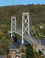
Simon Kenton Memorial Bridge

The Simon Kenton Memorial Bridge is a suspension bridge built in 1931 that carries U.S. Route 62 across the Ohio River to connect Maysville, Kentucky with Aberdeen, Ohio. Its main span is 1,060 feet (320 meters) long, and the total length of the bridge is 1,991 feet (607 meters). The bridge was designed by Modjeski and Masters and was open to traffic on November 25, 1931. Tolls were collected from the opening of the bridge until 1945. The bridge was closed for rehabilitation in 2003 and 2004 after the William H. Harsha Bridge was completed. URS Corp. prepared the rehabilitation plans which consisted of a deck replacement, structural steel repairs, a new inspection walkway, and a new handrail on the main spans. The bridge was painted and returned to its original color, silver. It was rumored that the bridge was painted green during World War II to help 'disguise' it from air attacks. National Engineering and Contracting Company completed the construction and painting for the rehabilitation at a cost of $5.7 million. In July 2019, The Kentucky Transportation Cabinet ordered a 3-ton weight limit placed on the bridge after a routine inspection found significant safety hazards with the cable suspension system. In November 2019, the bridge was closed due to corrosion in the suspension cable connectors. The bridge is expected to be repaired and put back in service by April 15, 2020. As of May 21, 2020, the bridge remained closed after an inspection of the cable repairs determined that the bridge needed rust-proofing. On June 12, 2020, the bridged reopened for traffic with a 15-ton weight restriction after being closed for nearly 6-months so a short-term fix could be done to reduce stress on 19 damaged and rust coated cables. The bridge is expected to undergo major rehabilitation work in the future, including replacing all cables.

Armstrong Row
Armstrong Row

Armstrong Row is a series of 11 brick row houses in Maysville, Kentucky built between 1820 and 1833 by John Armstrong, a local industrialist, entrepreneur and real estate developer. Vacant lots were purchased by an Armstrong owned company that operated the Maysville cotton mill. The company continued to operate as the January & Wood Company until 2003. Armstrong also developed a number of other row house projects in Maysville including the Federal style row houses on Limestone Street, Mechanic's Row, and the "Allen Block".The Armstrong Row houses are two story brick with gable roofs and stepped parapet walls in both Federal and Greek Revival style. The facade is Flemish bond and sides are common bond. Although similar in construction, the gable roofs vary in pitch suggesting the buildings were constructed either by more than one builder or over a period of time. John Armstrong was born in Ireland in 1779 and emigrated to America with his family circa 1790. He bought his first Maysville property in 1800 from Jacob Boone, a first cousin of Daniel Boone. He later operated several wholesale houses on front street becoming wealthy in the process.Armstrong was instrumental in the early development of the city and was the first to sign a petition to move the county seat from Washington to Maysville. He was a member of the company responsible for building the Maysville and Lexington Turnpike, he established the first bank in Kentucky in Maysville in 1818, and was a member of the committee that welcomed General Lafayette to Maysville in an 1825 visit.

Maysville roadcut
Maysville roadcut

The Maysville roadcut, located in northeastern Kentucky, features Upper Ordovician rock and fossils. Maysville is located in Mason County, Kentucky and contains a large roadcut along the U.S. Route 68 highway. The Maysville roadcut lies on the Clyde T. Barbour Parkway. The roadcut was human-made in the 1950s and consists of rock from the Ordovician period that is roughly 450 million years old. Maysville provides an opportunity to observe the stratigraphy of the formations present of the Ordovician time period. The roadcut is made up of three different formations: the Kope, Fairview, and Bellevue in ascending order. They are broken up into different layers that can be identified by different sediments and fossils present. The Maysville roadcut formations are made up primarily of shale and limestone. The abundance of each rock type differs amongst the three formations. Shale dominates in the Bellevue formation. Limestone is most prevalent in Fairview formation. A mix of limestone and shale is found in the Kope formation. There are a wide variety of invertebrate fossils that can be found at the Maysville roadcut, including trilobites, cephalopods, crinoids, gastropods, brachiopods, bryozoans. The abundance and presence of fossil types differs depending on the formation viewed. This is due to the differences in ecosystems and environmental conditions at the time of each formation. The Ordovician was a time when the land we know today was covered by a hot, shallow sea. The Cincinnati Arch, where Maysville can be found, was at about twenty three degrees south of the equator. Roadcuts such as Maysville roadcut have attracted those interested in collecting fossils, ranging from professionals at universities to amateurs in the area. Part of Maysville fossil collecting is fossil identification. Fossil identification books for Ohio and the Cincinnati area can serve as a resource. Furthermore, the Dry Dredgers is an amateur fossil collecting and geology group located in Cincinnati, Ohio. Their website also provides information for fossil identification.

Washington Opera House

The Washington Opera House is a 2 and 1/2 story structure near the western end of the main downtown shopping district of Maysville, Kentucky. The sides and rear of the theater are of red brick while the façade is of buff brick trimmed with red brick, stone, and cast iron. The tradition of theater in Mason County dates back to at least 1797 according to the Washington, Kentucky newspaper, The Mirror. The performance at the "Court House" is the first record of a stage performance west of the Alleghenies to disclose play titles, performance dates and prices. By 1817, there was a theater in Limestone (Maysville) at the corner of 2nd Street and Fish Street (now Wall Street).A disastrous fire destroyed a significant amount of property on West Second Street in April 1850 including the Presbyterian Church, then known as the Old Blue Church. The church congregation decided to rebuild on Third Street, leaving the Second Street lot vacant. In 1851, two fire companies were formed to prevent a repeat of the town fire and an elegant theater, "The Opera House", was built on the site of the Old Blue Church.In 1898, fire struck again and "The Opera House" was destroyed. Perhaps from remorse, the Washington Fire Company, organized at the time the theater was built - nearly five decades before, decided to rebuild it at a cost of $24,000 and the new structure was thereafter known as the "Washington Opera House".A number of famous artists and actors performed here including Marguerite Clark, Tom Mix, John L. Sullivan, and John Philip Sousa and his band. The Washington Opera continues as a theater and is currently home to the Maysville Players.