place

Wigan urban area

Geography of LancashireGeography of the Metropolitan Borough of WiganUrban areas of England
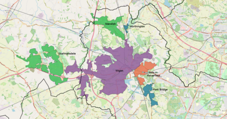
WiganBUA
WiganBUA

The Wigan Urban Area is an area of land defined by the Office for National Statistics consisting of the built-up, or 'urbanised' area containing Wigan in Greater Manchester and Skelmersdale in West Lancashire. The Urban Area includes the integrated conurbation around Wigan, (containing the contiguous areas of Ince-in-Makerfield and Wigan itself), along with the outlying areas of Standish, Abram and the West Lancashire town of Skelmersdale. The Wigan Urban Area has a total population of 175,405. This is an increase of 5% on the 2001 figure of 166,840.

Excerpt from the Wikipedia article Wigan urban area (License: CC BY-SA 3.0, Authors, Images).

Wigan urban area
King Street,

Geographical coordinates (GPS) Address Nearby Places
placeShow on map

Wikipedia: Wigan urban areaContinue reading on Wikipedia

Geographical coordinates (GPS)

Latitude Longitude
N 53.544 ° E -2.631 °
placeShow on map

Address

King Street 29-33
WN1 1DY , Wallgate
England, United Kingdom
mapOpen on Google Maps

WiganBUA
WiganBUA
Share experience

Nearby Places

Wigan
Wigan

Wigan ( WIG-ən) is a large town in Greater Manchester, England, on the River Douglas. The town is midway between the two cities of Manchester, 16 miles (25.7 km) to the south east, and Liverpool, 17 miles (27 km) to the southwest. The towns of Bolton to the northeast, and Warrington to the south are 10 miles (16 km) and 12 miles (19 km) away respectively. Within the boundaries of the historic county of Lancashire, Wigan is the largest settlement in the Metropolitan Borough of Wigan and its administrative centre. The town has a population of 107,732 and the wider borough of 330,713.Wigan was in the territory of the Brigantes, an ancient Celtic tribe that ruled much of what is now northern England. The Brigantes were subjugated in the Roman conquest of Britain and the Roman settlement of Coccium established where Wigan lies. Wigan was incorporated as a borough in 1246, following the issue of a charter by King Henry III of England. At the end of the Middle Ages, it was one of four boroughs in Lancashire established by Royal charter. The Industrial Revolution saw a dramatic economic expansion and rapid rise in population. Wigan became a major mill town and coal mining district; at its peak, there were 1,000 pit shafts within 5 miles (8 km) of the town centre. Coal mining ceased in the later 20th century. Wigan Pier, a wharf on the Leeds and Liverpool Canal, was made famous by the writer George Orwell. In his book The Road to Wigan Pier, Orwell highlighted the poor working and living conditions of inhabitants in the 1930s. Following the decline of heavy industry, Wigan Pier's warehouses and wharves became a local heritage centre and cultural quarter. The DW Stadium is home to Wigan Athletic Football Club and Wigan Warriors Rugby League Football Club.