place

Denver

1858 establishments in Kansas TerritoryCities in ColoradoColorado countiesConsolidated city-countiesCounty seats in Colorado
DenverDenver metropolitan areaPages with non-numeric formatnum argumentsPopulated places established in 1858Railway towns in ColoradoUse American English from September 2020Use mdy dates from February 2021Wikipedia indefinitely move-protected pages
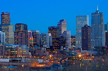
Denver skyline
Denver skyline

Denver () is a consolidated city and county, the capital, and most populous city of the U.S. state of Colorado. Its population was 715,522 at the 2020 United States census, a 19.22% increase since the 2010 United States census. It is the 19th-most populous city in the United States and the fifth most populous state capital. It is the principal city of the Denver–Aurora–Lakewood, CO Metropolitan Statistical Area and the first city of the Front Range Urban Corridor. Denver is located in the Southwestern United States, in the South Platte River Valley on the western edge of the High Plains just east of the Front Range of the Rocky Mountains. Its downtown district is immediately east of the confluence of Cherry Creek and the South Platte River, approximately 12 mi (19 km) east of the foothills of the Rocky Mountains. It is named after James W. Denver, a governor of the Kansas Territory. It is nicknamed the Mile High City because its official elevation is exactly one mile (5280 feet or 1609.344 meters) above sea level. The 105th meridian west of Greenwich, the longitudinal reference for the Mountain Time Zone, passes directly through Denver Union Station. Denver is ranked as a Beta world city by the Globalization and World Cities Research Network. The 10-county Denver-Aurora-Lakewood, CO Metropolitan Statistical Area had a population of 2,963,821 at the 2020 United States Census, making it the 19th most populous U.S. metropolitan statistical area. The 12-county Denver-Aurora, CO Combined Statistical Area had a population of 3,623,560 at the 2020 United States Census, making it the 17th most populous U.S. primary statistical area. Denver is the most populous city of the 18-county Front Range Urban Corridor, an oblong urban region stretching across two states with a population of 5,055,344 at the 2020 United States Census. Its metropolitan area is the most populous metropolitan area within an 560-mile (900 km) radius and the second most populous city in the Mountain West after Phoenix, Arizona. In 2016, it was named the best place to live in the United States by U.S. News & World Report.

Excerpt from the Wikipedia article Denver (License: CC BY-SA 3.0, Authors, Images).

Denver
East Colfax Avenue, Denver

Geographical coordinates (GPS) Address Nearby Places
placeShow on map

Wikipedia: DenverContinue reading on Wikipedia

Geographical coordinates (GPS)

Latitude Longitude
N 39.7392 ° E -104.985 °
placeShow on map

Address

State Capitol Building

East Colfax Avenue 200
80203 Denver
Colorado, United States
mapOpen on Google Maps

Denver skyline
Denver skyline
Share experience

Nearby Places

List of Denver RTD rail stations

The Regional Transportation District (RTD) operates a mass transit network, serving portions of Denver, Colorado, United States, and its surrounding metropolitan area, with light rail and commuter rail services. As of December 2022, the 113-mile (182 km) urban rail transit system includes 74 stations on 10 lines: A, B, D, E, G, H, L, N, R, and W. In first quarter of 2016, the six light rail lines served an average 79,600 passengers a day, making the RTD light rail the eighth-largest light rail system in the United States in terms of ridership.All of the stations are open-air structures featuring passenger canopies for protection from adverse weather conditions. The RTD has established criteria for station design with the intention of incorporating each station effectively into its surrounding community. All stations feature three elements according to the criteria: the platform, its transition plaza and the intermodal passenger transport available to and from the facility. Platforms are designed to accommodate four-car trains and may be in either a side, island or side center style. The transition plaza is the area where passenger services can be found between the platform and where intermodal access is available. All stations are decorated with works of public art as part of the RTD's "Art-n-Transit" program. They include independent works as well as pieces incorporated into the canopies, columns, pavers, windscreens, fencing and landscaping.Light rail service began on October 8, 1994, with the opening of the initial fourteen stations on the 5.3-mile (8.5 km) Central Corridor segment from 30th & Downing station to I-25 & Broadway station. The first extension opened on July 14, 2000, and included the completion of an additional 8.7 miles (14.0 km) of rail and five stations through its present southern terminus at Littleton–Mineral station. In 2002, a four station, 1.8-mile (2.9 km) spur through the Central Platte Valley opened between the 10th & Osage station and Union Station. By November 2006, expansion to the southeast saw the completion of 19 miles (31 km) of rail and thirteen stations between I-25 & Broadway and both Nine Mile station in Aurora and Lincoln in Lone Tree. On April 26, 2013 the W Line was opened which added 12.1 miles (19.5 km) of rail and eleven stations between Auraria West station and the Jefferson County Government Center–Golden station in Golden, Colorado. The first commuter rail line, the A Line to Denver Airport station, opened on April 22, 2016.Rail services use a zone-based fare system, where passengers are charged based on the number of zones through which they are traveling. Fare zones are noted A, B, and C, based on distance from Downtown Denver, with a separate airport zone for travel to and from Denver Airport station.