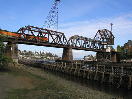
Salmon Bay Bridge

The Salmon Bay Bridge, also known as Bridge No. 4, is a Strauss Heel-trunnion single-leaf bascule bridge spanning across Salmon Bay and connecting Magnolia/Interbay to Ballard in Seattle, Washington. The bridge is located just west of Commodore Park. It carries the main line of the BNSF Railway on its way north to Everett and south to King Street Station and Seattle's Industrial District. The Salmon Bay Bridge, which is located west of the Hiram M. Chittenden Locks, is the last bridge to span the Lake Washington Ship Canal before it becomes Puget Sound. Built in 1914 by the Great Northern Railway, it has an opening span of 61 meters (200 feet) and has two tracks. Additionally, vessel clearance when lowered is 13.1 meters (43 feet) at mean high tide, and up to 15.3 meters (50 feet) at low tide.BNSF Railway initially planned to replace the Salmon Bay Bridge with a new vertical-lift bridge, but chose to repair failing components of the existing bridge following consultation with the local community.
Excerpt from the Wikipedia article Salmon Bay Bridge (License: CC BY-SA 3.0, Authors, Images).Salmon Bay Bridge
West Commodore Way, Seattle Ballard
Geographical coordinates (GPS) Address Nearby Places Show on map
Geographical coordinates (GPS)
| Latitude | Longitude |
|---|---|
| N 47.6668 ° | E -122.40213 ° |
Address
Salmon Bay Bridge (Bridge 6.3)
West Commodore Way
98017 Seattle, Ballard
Washington, United States
Open on Google Maps


