place

Denver–Aurora combined statistical area

Denver metropolitan areaMetropolitan areas of Colorado
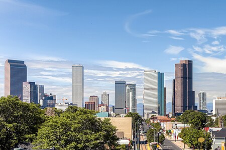
Downtown denver
Downtown denver

The United States Office of Management and Budget has defined the 12-county Denver–Aurora, CO Combined Statistical Area comprising the Denver–Aurora–Lakewood, CO Metropolitan Statistical Area, the Boulder, CO Metropolitan Statistical Area, and the Greeley, CO Metropolitan Statistical Area. The United States Census Bureau estimates that the population was 3,214,218 as of July 1, 2012, an increase of +3.99% since the 2010 United States Census, and ranking as the 16th most populous metropolitan combined statistical area and the 17th most populous primary statistical area of the United States. The population estimate for 2016 is 3,412,607.

Excerpt from the Wikipedia article Denver–Aurora combined statistical area (License: CC BY-SA 3.0, Authors, Images).

Denver–Aurora combined statistical area
East Colfax Avenue, Denver

Geographical coordinates (GPS) Address Nearby Places
placeShow on map

Wikipedia: Denver–Aurora combined statistical areaContinue reading on Wikipedia

Geographical coordinates (GPS)

Latitude Longitude
N 39.7392166 ° E -104.9849171 °
placeShow on map

Address

State Capitol Building

East Colfax Avenue 200
80203 Denver
Colorado, United States
mapOpen on Google Maps

Downtown denver
Downtown denver
Share experience

Nearby Places

Denver metropolitan area

Denver is the central city of a conurbation region in the U.S. state of Colorado. The conurbation includes one continuous region consisting of the six central counties of Adams, Arapahoe, Broomfield, Denver, Douglas, and Jefferson. The Denver region is part of the Front Range Urban Corridor. The United States Office of Management and Budget has delineated the Denver–Aurora–Lakewood, CO Metropolitan Statistical Area consisting of ten Colorado counties: the City and County of Denver, Arapahoe County, Jefferson County, Adams County, Douglas County, the City and County of Broomfield, Elbert County, Park County, Clear Creek County, and Gilpin County. The population, as of the 2020 Census, is 2,963,821, and increase of 16.5% since 2010.The Office of Management and Budget also delineated the more extensive 12-county Denver–Aurora, CO Combined Statistical Area comprising the Denver-Aurora-Lakewood Metropolitan Statistical Area, the Boulder, CO Metropolitan Statistical Area, and the Greeley, CO Metropolitan Statistical Area.The central part of the metropolitan statistical area (MSA) includes Denver and three immediately adjacent counties: Jefferson County to the west, Adams County to the north and east, and Arapahoe County to the south and east. The continuously urbanized area extends northwest into the City and County of Broomfield, bordering Jefferson and Adams counties, and south into Douglas County, adjoining Arapahoe County. Also included in the federally defined MSA are four rural counties: Elbert County on the southeastern prairie and Clear Creek, Gilpin, and Park counties in the Rocky Mountains.

List of Denver RTD rail stations

The Regional Transportation District (RTD) operates a mass transit network, serving portions of Denver, Colorado, United States, and its surrounding metropolitan area, with light rail and commuter rail services. As of December 2022, the 113-mile (182 km) urban rail transit system includes 74 stations on 10 lines: A, B, D, E, G, H, L, N, R, and W. In first quarter of 2016, the six light rail lines served an average 79,600 passengers a day, making the RTD light rail the eighth-largest light rail system in the United States in terms of ridership.All of the stations are open-air structures featuring passenger canopies for protection from adverse weather conditions. The RTD has established criteria for station design with the intention of incorporating each station effectively into its surrounding community. All stations feature three elements according to the criteria: the platform, its transition plaza and the intermodal passenger transport available to and from the facility. Platforms are designed to accommodate four-car trains and may be in either a side, island or side center style. The transition plaza is the area where passenger services can be found between the platform and where intermodal access is available. All stations are decorated with works of public art as part of the RTD's "Art-n-Transit" program. They include independent works as well as pieces incorporated into the canopies, columns, pavers, windscreens, fencing and landscaping.Light rail service began on October 8, 1994, with the opening of the initial fourteen stations on the 5.3-mile (8.5 km) Central Corridor segment from 30th & Downing station to I-25 & Broadway station. The first extension opened on July 14, 2000, and included the completion of an additional 8.7 miles (14.0 km) of rail and five stations through its present southern terminus at Littleton–Mineral station. In 2002, a four station, 1.8-mile (2.9 km) spur through the Central Platte Valley opened between the 10th & Osage station and Union Station. By November 2006, expansion to the southeast saw the completion of 19 miles (31 km) of rail and thirteen stations between I-25 & Broadway and both Nine Mile station in Aurora and Lincoln in Lone Tree. On April 26, 2013 the W Line was opened which added 12.1 miles (19.5 km) of rail and eleven stations between Auraria West station and the Jefferson County Government Center–Golden station in Golden, Colorado. The first commuter rail line, the A Line to Denver Airport station, opened on April 22, 2016.Rail services use a zone-based fare system, where passengers are charged based on the number of zones through which they are traveling. Fare zones are noted A, B, and C, based on distance from Downtown Denver, with a separate airport zone for travel to and from Denver Airport station.