place

Woodhouse Mill railway station

Disused railway stations in RotherhamFormer Midland Railway stationsPages with no open date in Infobox stationRailway stations in Great Britain closed in 1953Railway stations in Great Britain opened in 1840
Use British English from March 2015Yorkshire and the Humber railway station stubs
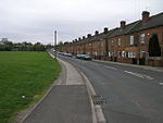
Woodhouse Mill railway station (site), Yorkshire (geograph 3584358)

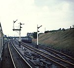
Woodhouse Mill railway station was opened in 1840 by the North Midland Railway on its line between Rotherham Masborough and Chesterfield. It was situated to the south of the main A57 road shortly after this left the City of Sheffield and served Woodhouse Mill, near Sheffield, Orgreave, Fence and (Aston cum Aughton), all within Rotherham, South Yorkshire. It may initially have been simply a halt, but the Midland Railway installed an island platform with a timber and brick booking office at its centre. Nearby was Orgreave Coke Works and Fence Colliery. It closed in 1953.The station was located between that at Treeton and the original North Midland station at Beighton. The line is still in use today but has been a freight only route since July 1954, although it is very occasionally used as a diversionary route and by excursions not calling at Sheffield. It serves as a bypass line which keeps freight trains away from the congested lines through central Sheffield.

Excerpt from the Wikipedia article Woodhouse Mill railway station (License: CC BY-SA 3.0, Authors, Images).

Woodhouse Mill railway station
Retford Road,

Geographical coordinates (GPS) Address External links Nearby Places
placeShow on map

Wikipedia: Woodhouse Mill railway stationContinue reading on Wikipedia

Geographical coordinates (GPS)

Latitude Longitude
N 53.36808 ° E -1.34637 °
placeShow on map

Address

Woodhouse Mill

Retford Road
S13 9WG , Aston cum Aughton
England, United Kingdom
mapOpen on Google Maps

linkWikiData (Q8032755)
linkOpenStreetMap (8600106887)

Woodhouse Mill railway station (site), Yorkshire (geograph 3584358)
Share experience

Nearby Places

Rother Vale Collieries

Rother Vale Collieries were a group of coal producing pits originally in the Rother Valley parishes of Treeton, Woodhouse and Orgreave, nowadays on the south east Sheffield / Rotherham boundary, in South Yorkshire, England. In the early 20th century a new colliery at Thurcroft was developed. The Fence Colliery Company was formed in 1862 with the purchase of Fence Colliery, a small coal pit sunk alongside the main Sheffield to Worksop road at the lower end of the village of Fence. This pit had already been in operation for over 20 years and under new ownership was considerably developed. It closed as a coal producing unit in 1904, coal from its reserves being brought to the surface at Orgreave, but it was retained as a pumping station and later became the National Coal Boards workshops, finally closing in the 1990s. Orgreave Colliery, then a small concern, was bought by the company in 1870. It was situated less than a mile from Fence, adjacent to the main line of the Manchester, Sheffield and Lincolnshire Railway, to the west of Woodhouse. It was joined to this railway by a steeply graded but short branch line. Five years after the purchase of Orgreave colliery the company changed its name and became Rother Vale Collieries Limited extending its empire just two years on with the sinking of a new pit at Treeton. A railway branch was constructed by well-known contractors Logan and Hemingway between Orgreave and Treeton to link the collieries to the Midland Railway at Treeton. In order to gain a foothold in the traffic at Treeton the M.S.& L.R. gained authorisation for a branch line, unusually, under its "Extension to London" Act, 1893. This opened for traffic, including the Paddy Mail, on 10 October 1898. Moving further eastwards the Rother Vale Colliery Company began the sinking of a new colliery at Thurcroft in 1909. Although the Barnsley seam was reached in 1913 extraction became difficult. The point of sinking was situated over a large geological fault which had thrown the coal out of its normal position. In 1918 the United Steel Companies was formed and the following year, along with steel making interests in South Yorkshire and Lincolnshire, Rother Vale Collieries became part of the group.

Ochre Dyke

The Ochre Dyke is a small stream in the south eastern part of the City of Sheffield in South Yorkshire, England. It rises some 100m to the east/south east of the ruined barn known as Eckington Lees. This is at the extreme western end of Birley Wood Golf Course. Ochre Dyke flows east/south east along the southern border of the golf course and passes through Birley Wood; up to this point it is the county boundary between South Yorkshire and North East Derbyshire. During summer months the brook frequently dries up to this point. The Ochre dyke gets its name from the pollution of the water by yellow ochre (Iron Oxide) as a result of coal mining activity in the upper reaches of the valley. The area in and around Birley wood was extensively mined for coal and black-band iron ore from at least the medieval period up to the mid 20th century when Dent Main Colliery closed. Other mines along the course of the stream were Moorhole Colliery East, Moorhole Colliery North and Moorhole Colliery South. After passing Birley Moor Road, the brook flows through Owlthorpe, past the Crystal Peaks shopping centre, before heading into Beighton and passing beneath Sothall Green at its junction with the main road. The stream eventually flows into the River Rother.The Ochre Dyke has never been used for powering Sickle grinding wheels, unlike the nearby Shire Brook which has hosted several wheels including the Nether Wheel, Carr Forge, Rainbow Forge and Cliff Wheel. The Cliff Wheel was located along the stream and was used for grinding.