place

Santa Cruz, California

1791 establishments in Alta California1866 establishments in CaliforniaBusking venuesCities in Santa Cruz County, CaliforniaCounty seats in California
Incorporated cities and towns in CaliforniaMonterey BayPopulated coastal places in CaliforniaPopulated places established in 1791Populated places established in 1866Santa Cruz, CaliforniaSpanish mission settlements in North AmericaUse mdy dates from November 2023
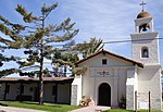
Santa Cruz, California, USA Mission Santa Cruz 144 School St, Santa Cruz, CA 95060 panoramio (cropped)

Santa Cruz (Spanish for "Holy Cross") is the largest city and the county seat of Santa Cruz County, in Northern California. As of the 2020 census, the city population was 62,956. Situated on the northern edge of Monterey Bay, Santa Cruz is a popular tourist destination, owing to its beaches, surf culture, and historic landmarks. Santa Cruz was founded by the Spanish in 1791, when Fermín de Lasuén established Mission Santa Cruz. Soon after, a settlement grew up near the mission called Branciforte, which came to be known across Alta California for its lawlessness. With the Mexican secularization of the Californian missions in 1833, the former mission was divided and granted as rancho grants. Following the American Conquest of California and the admission of California as a U. S. state in 1850, Santa Cruz was incorporated as a town in 1866, and became a charter city in 1876. The creation of the Santa Cruz Beach Boardwalk in 1904 solidified the city's status as a seaside resort community, while the establishment of the University of California, Santa Cruz in 1965 made Santa Cruz a college town.

Excerpt from the Wikipedia article Santa Cruz, California (License: CC BY-SA 3.0, Authors, Images).

Santa Cruz, California
Virginia Alley, Santa Cruz Downtown

Geographical coordinates (GPS) Address Nearby Places
placeShow on map

Wikipedia: Santa Cruz, CaliforniaContinue reading on Wikipedia

Geographical coordinates (GPS)

Latitude Longitude
N 36.971944444444 ° E -122.02638888889 °
placeShow on map

Address

Cedar/Cathcart Parking Lot

Virginia Alley
95061 Santa Cruz, Downtown
California, United States
mapOpen on Google Maps

Santa Cruz, California, USA Mission Santa Cruz 144 School St, Santa Cruz, CA 95060 panoramio (cropped)
Share experience

Nearby Places

Santa Cruz Civic Auditorium

The Santa Cruz Civic Auditorium is an event and convention venue located in downtown Santa Cruz, California. It is owned by the City of Santa Cruz and is located at 307 Church Street. Opened in 1940, it was built in what was described as, "Mission-style in architecture with a modern touch and an arrangement of open porches on the corners and sides." Its style has also been described as Art Deco. It is the home of the Santa Cruz County Symphony as well as other concerts, expos, conferences, and sporting events. A carillon was installed in 1963.In 1956, the Santa Cruz Civic Auditorium was the location of a rock and roll concert that drew national attention after the local police stopped the event because of what they characterized as the dancers' "suggestive, stimulating and tantalizing motions".The Santa Cruz Civic Auditorium was the site of the annual Miss California beauty pageant from 1966 until 1985, when the pageant left Santa Cruz after years of protests and a "Myth California" counter-pageant organized by local feminist activists led by Ann Simonton and Nikki Craft.In 1984, artist Guillermo Wagner Granizo donated a ceramic tile mural entitled, "A Gift of Appreciation to this Area," which featured imagery of past events at the Santa Cruz Civic Auditorium.The auditorium was used as a temporary shelter for displaced and homeless people following the 1989 Loma Prieta earthquake. It was used for this purpose again in 2020 during the CZU Lightning Complex fires.