place

Column of Marcian

5th-century inscriptions5th-century sculpturesBuildings and structures completed in the 5th centuryFatihLatin inscriptions
Monumental columns in IstanbulRoman victory columns
ColumnOfMarcianInIstanbulApril2007

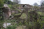
The Column of Marcian (Turkish: Kıztaşı) is a Roman honorific column erected in Constantinople by the praefectus urbi Tatianus (450-c.452) and dedicated to the Emperor Marcian (450-57). It is located in the present-day Fatih district of Istanbul. The column is not documented in any late Roman or Byzantine source and its history has to be inferred from its location, style and dedicatory inscription. The column is carved from red-grey Egyptian granite, in two sections. The quadrilateral basis is encased by four slabs of white marble. Three faces are decorated with IX monograms within medallions, and the fourth with two genii supporting a globe. The column is topped by a Corinthian capital, decorated with aquilae. The inscription confirms that the capital was originally surmounted by a statue of Marcian, in continuation of an imperial architectural tradition initiated by the Column of Trajan and the Column of Marcus Aurelius in Rome. The basis of the column is orientated northwest/southeast, while its capital is aligned north/south, possibly so that the statue could look towards the nearby Church of the Holy Apostles. A Latin dedicatory inscription is engraved on the northern side of the basis. Its lettering was originally filled with bronze, which has since been removed. The inscription reads: [PR]INCIPIS HANC STATUAM MARCIANI | CERNE TORUMQUE | [PRAE]FECTUS VOVIT QUOD TATIANUS | OPUS (Behold this statue of the princeps Marcian and its base,a work dedicated by the prefect Tatianus.) The Turkish name Kıztaşı, "the column of the girl" (kız: "girl" + taş: "stone"), apparently derives from the genii on the basis, which during the Ottoman period were the column's most distinguishing features (after the loss of Marcian's statue).

Excerpt from the Wikipedia article Column of Marcian (License: CC BY-SA 3.0, Authors, Images).

Column of Marcian
Kızanlık Caddesi, Istanbul

Geographical coordinates (GPS) Address Phone number Nearby Places
placeShow on map

Wikipedia: Column of MarcianContinue reading on Wikipedia

Geographical coordinates (GPS)

Latitude Longitude
N 41.0155 ° E 28.9502 °
placeShow on map

Address

Cafe Dolen Pasta

Kızanlık Caddesi
34080 Istanbul
Türkiye
mapOpen on Google Maps

Phone number

call02125213033

ColumnOfMarcianInIstanbulApril2007
Share experience

Nearby Places

Istanbul
Istanbul

Istanbul ( IST-an-BUUL, US also IST-an-buul; Turkish: İstanbul [isˈtanbuɫ] (listen)), formerly known as Constantinople, is the largest city in Turkey, serving as the country's economic, cultural and historic hub. The city straddles the Bosporus strait, lying in both Europe and Asia, and has a population of over 15 million residents, comprising 19% of the population of Turkey. Istanbul is the most populous European city, and the world's 15th-largest city. The city was founded as Byzantium (Byzantion) in the 7th century BCE by Greek settlers from Megara. In 330 CE, the Roman emperor Constantine the Great made it his imperial capital, renaming it first as New Rome (Nova Roma) and then as Constantinople (Constantinopolis) after himself. The city grew in size and influence, eventually becoming a beacon of the Silk Road and one of the most important cities in history. The city served as an imperial capital for almost 1600 years: during the Roman/Byzantine (330–1204), Latin (1204–1261), late Byzantine (1261–1453), and Ottoman (1453–1922) empires. The city played a key role in the advancement of Christianity during Roman/Byzantine times, hosting four (including Chalcedon (Kadıköy) on the Asian side) of the first seven ecumenical councils (all of which were in present-day Turkey) before its transformation to an Islamic stronghold following the Fall of Constantinople in 1453 CE—especially after becoming the seat of the Ottoman Caliphate in 1517.In 1923, after the Turkish War of Independence, Ankara replaced the city as the capital of the newly formed Republic of Turkey. In 1930, the city's name was officially changed to Istanbul, the Turkish rendering of the appellation Greek speakers used since the eleventh century to colloquially refer to the city.Over 13.4 million foreign visitors came to Istanbul in 2018, eight years after it was named a European Capital of Culture, making it the world's eighth most visited city. Istanbul is home to several UNESCO World Heritage Sites, and hosts the headquarters of numerous Turkish companies, accounting for more than thirty percent of the country's economy.

Aqueduct of Valens
Aqueduct of Valens

The Aqueduct of Valens (Turkish: Valens Su Kemeri, Ancient Greek: Ἀγωγὸς τοῦ ὕδατος, romanized: Agōgós tou hýdatos, lit. 'aqueduct') was a Roman aqueduct system built in the late 4th century AD, to supply Constantinople – the capital of the eastern Roman empire. Construction of the aqueduct began during the reign of the Roman emperor Constantius II (r. 337–361) and was completed in 373 by the emperor Valens (r. 364–378). The aqueduct remained in use for many centuries. It was extended and maintained by the Byzantines and the Ottomans. Initially, the Aqueduct of Valens carried water from springs at Danımandere and Pınarca; the channels from each spring met at Dağyenice. This 4th-century first phase of the system was 268 kilometres (167 miles) long. A second, 5th-century phase added a further 451 kilometres (280 miles) of conduits that took water from Vize, 120 kilometres (75 miles) away from Constantinople.: 13 The final and most visible aqueduct bridge in the system survives in the Fatih district of Istanbul, Turkey. Named in Turkish: Bozdoğan Kemeri, lit. 'Aqueduct of the Grey Falcon', it is an important landmark in the city, with its arches passing over Atatürk Boulevard (Atatürk Bulvarı). The Bozdoğan Kemeri spans the valley between the hills that are today occupied by the Istanbul University and the Fatih Mosque, formerly the site of the Church of the Holy Apostles. The surviving section is 921 metres long, about 50 metres less than the original length.

Constantinople
Constantinople

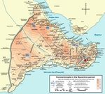
Constantinople (; Greek: Κωνσταντινούπολις Kōnstantinoupolis; Latin: Constantinopolis; Ottoman Turkish: قسطنطينيه‎, romanized: Ḳosṭanṭīnīye) was the capital of the Roman/Byzantine Empire (330–1204 and 1261–1453), the Latin Empire (1204–1261), and the Ottoman Empire (1453–1922). The capital then moved to Ankara following the Turkish War of Independence. Officially renamed Istanbul in 1930, the city is today the largest city and financial centre of the Republic of Turkey (1923–present). It remains the largest city in Europe. In 324, the ancient city of Byzantium was renamed "New Rome" and declared the new capital of the Roman Empire by Emperor Constantine the Great, after whom it was renamed, and dedicated on 11 May 330. Constantinople is generally considered to be the center and the "cradle of Orthodox Christian civilization". From the mid-5th century to the early 13th century, Constantinople was the largest and wealthiest city in Europe. The city became famous for its architectural masterpieces, such as Hagia Sophia, the cathedral of the Eastern Orthodox Church, which served as the seat of the Ecumenical Patriarchate, the sacred Imperial Palace where the Emperors lived, the Galata Tower, the Hippodrome, the Golden Gate of the Land Walls, and opulent aristocratic palaces. The University of Constantinople was founded in the fifth century and contained artistic and literary treasures before it was sacked in 1204 and 1453, including its vast Imperial Library which contained the remnants of the Library of Alexandria and had 100,000 volumes. The city was the home of the Ecumenical Patriarch of Constantinople and guardian of Christendom's holiest relics such as the Crown of thorns and the True Cross. Constantinople was famed for its massive and complex fortifications, which ranked among the most sophisticated defensive architecture of Antiquity. The Theodosian Walls consisted of a double wall lying about 2 kilometres (1.2 mi) to the west of the first wall and a moat with palisades in front. Constantinople's location between the Golden Horn and the Sea of Marmara reduced the land area that needed defensive walls. The city was built intentionally to rival Rome, and it was claimed that several elevations within its walls matched Rome's 'seven hills'. The impenetrable defenses enclosed magnificent palaces, domes, and towers, the result of prosperity Constantinople achieved as the gateway between two continents (Europe and Asia) and two seas (the Mediterranean and the Black Sea). Although besieged on numerous occasions by various armies, the defenses of Constantinople proved impenetrable for nearly nine hundred years. In 1204, however, the armies of the Fourth Crusade took and devastated the city and, for several decades, its inhabitants resided under Latin occupation in a dwindling and depopulated city. In 1261 the Byzantine Emperor Michael VIII Palaiologos liberated the city, and after the restoration under the Palaiologos dynasty, it enjoyed a partial recovery. With the advent of the Ottoman Empire in 1299, the Byzantine Empire began to lose territories and the city began to lose population. By the early 15th century, the Byzantine Empire was reduced to just Constantinople and its environs, along with Morea in Greece, making it an enclave inside the Ottoman Empire; after a 53-day siege the city eventually fell to the Ottomans, led by Sultan Mehmed II, on 29 May 1453, whereafter it replaced Edirne (Adrianople) as the new capital of the Ottoman Empire.