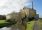
The River Frome, once also known as the Stroudwater, is a small river in Gloucestershire, England. It is to be distinguished from another River Frome in Gloucestershire, the Bristol Frome, and the nearby River Frome, Herefordshire. The river is approximately 25 miles (40 km) long.It flows broadly westwards, from its source high up on the Cotswold escarpment, initially through a narrow, steep-sided valley, which it shares with the Thames and Severn Canal and the Golden Valley line railway. Below Stroud, the main town on the river, it is swelled by flows from several tributaries, and the valley opens out, with the channel splitting into two before reuniting into a single channel. The river, as well as its tributaries, has been used for milling since the time of the Domesday Book. Some early mills were used for milling corn but subsequently the river was important for the woollen industry, until that experienced a series of depressions in the early 19th century. The area then became known for the production of walking sticks and umbrella sticks, an industry that lasted into the mid-20th century. Steam engines were installed from the 1810s onwards, but were often used to assist when water power was insufficient, rather than to replace water power. Despite the demise of milling, many mill buildings survive along the course of the river, a significant number of which are listed buildings, in recognition of their architecture.
The river has undergone modification over the years, not least to power the mills. There was an early attempt to make it navigable as far as Stroud, using cranes to move containers from boats at one level to those at another level, at places where a mill dam prevented through navigation. The scheme was abandoned before it was completed, due to the cost of construction and the time taken to tranship the containers. Communication was later provided by the Stroudwater Navigation, a separate canal which followed the route of the river from the River Severn to Wallbridge and opened in 1779. This was later extended through to the River Thames by the construction of the Thames and Severn Canal, which opened in 1789. Both are now part of the Cotswold Canals Trust, and are being restored. A small part of both canals near their junction is classified as a main river, because three of the tributaries of the Frome were diverted into them in the 1950s as part of a flood prevention scheme.
Despite the number of historical weirs and modern flood defence structures, the river is not classified as heavily modified, although the modification of its channel, together with the volume of water abstracted to supply the canals and for the drinking water industry, mean that its water quality is only rated moderate under the terms of the Water Framework Directive, as both factors affect the ability of fish to move freely along the river.


