Downtown Detroit

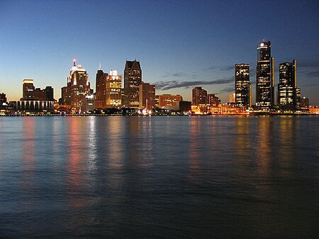
Downtown Detroit is the central business district and a residential area of the city of Detroit, Michigan, United States. Locally, downtown tends to refer to the 1.4 square mile region bordered by M-10 (Lodge Freeway) to the west, Interstate 75 (I-75, Fisher Freeway) to the north, I-375 (Chrysler Freeway) to the east, and the Detroit River to the south. Although, it may also refer to the Greater Downtown area, a 7.2 square mile region that includes surrounding neighborhoods such as Midtown, Corktown, Rivertown, and Woodbridge. The city's main thoroughfare M-1 (Woodward Avenue) links Downtown to Midtown, New Center, and the North End. Downtown contains much historic architecture, including prominent skyscrapers, ranging from the Renaissance Center, the Penobscot Building, One Detroit Center, and the Guardian Building. Historic churches, theatres, and commercial buildings anchor the various downtown districts. Downtown has a number of parks including those linked by a promenade along the International Riverfront. Its central square is Campus Martius Park.
Excerpt from the Wikipedia article Downtown Detroit (License: CC BY-SA 3.0, Authors, Images).Downtown Detroit
Detroit
Geographical coordinates (GPS) Address Nearby Places Show on map
Geographical coordinates (GPS)
| Latitude | Longitude |
|---|---|
| N 42.333888888889 ° | E -83.047777777778 ° |
Address
48226 Detroit
Michigan, United States
Open on Google Maps


