Trebević

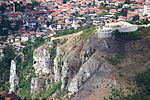
Trebević (Serbian Cyrillic: Требевић) is a mountain in central Bosnia and Herzegovina, located in the territories of Sarajevo and East Sarajevo city, bordering Jahorina mountain. Trebević is 1,627 meters (5,338 ft) tall, making it the second shortest of the Sarajevo mountains. During the Middle Ages, Trebević was known as Zlatni Do. During the 1984 Winter Olympics Trebević, like the other Sarajevo mountains, was used for several Olympic events, such as bobsledding. Trebević today is important as a tourist destination for citizens of Sarajevo as Igman or Bjelašnica. Most of the land mines are now cleared from heavy fighting that took place in the early 1990s. There are a few hotels, mountaineering homes, and other such structures on Trebević and the immediate area. The mountain is very popular for family picnics, hiking, climbing, mountain biking and it has a downhill track for local and international skiing competitions.Trebević has been the main excursion site for Sarajevo citizens due to the favorable geographical position, climate and the beauty of the nature. The biological diversity is among the highest and it is extraordinary to find such a phenomenon near the heart of the big city. On 9 April 2014, Sarajevo Canton Assembly declared Trebević a protected area, in order to conserve and improve each element of the geographical and biological diversity.Trebević can be reached from Sarajevo by the Trebević Cable Car, which starts from the neighbourhood of Bistrik.
Excerpt from the Wikipedia article Trebević (License: CC BY-SA 3.0, Authors, Images).Trebević
Barer Straße, München Maxvorstadt
Geographical coordinates (GPS) Address Website Nearby Places Show on map
 Continue reading on Wikipedia
 Geographical coordinates (GPS)
| Latitude | Longitude |
|---|---|
| N 43.818611111111 ° | E 18.46 ° |
Address
echt jetzt
Barer Straße
80799 München, Maxvorstadt
Bayern, Deutschland
Open on Google Maps
Website
echtjetzt-echtjetzt.de