place

East Bay Municipal Utility District
1923 establishments in CaliforniaEast Bay Municipal Utility DistrictGovernment agencies established in 1923Government in the San Francisco Bay AreaGovernment of Alameda County, California
Government of Contra Costa County, CaliforniaOrganizations based in Oakland, CaliforniaPublic utilities of the United StatesSewage treatment plants in CaliforniaSpecial districts of CaliforniaWater companies of the United StatesWater in CaliforniaWater management authorities in California
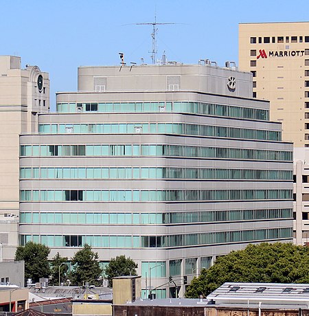
Ebmudheadquarters
Ebmudheadquarters

East Bay Municipal Utility District (EBMUD), colloquially referred to as "East Bay Mud", is a public utility district which provides water and sewage treatment services for an area of approximately 331 square miles (860 km2) in the eastern side of the San Francisco Bay. As of 2018, EBMUD provides drinking water for approximately 1.4 million people in portions of Alameda County and Contra Costa County in California, including the cities of Richmond, El Cerrito, Hercules, San Pablo, Pinole, Lafayette, Moraga, Orinda, Danville, Oakland, Piedmont, Emeryville, Berkeley, Albany, Alameda, San Leandro, neighboring unincorporated regions, and portions of cities such as Hayward and San Ramon. Sewage treatment services are provided for 685,000 people in an 88-square-mile area (as of 2018). EBMUD currently has an average annual growth rate of 0.8% and is projected to serve 1.6 million people by 2030. Headquartered in Oakland, EBMUD owns and maintains 2 water storage reservoirs on the Mokelumne River, 5 terminal reservoirs, 91 miles (146 km) of water transmission aqueducts, 4,100 miles (6,600 km) of water mains, 6 water treatment plants (WTPs), 29 miles (47 km) of wastewater interceptor sewer lines and a regional wastewater treatment facility (WWTF) rated at a maximum treatment capacity of 320 MGD.

Excerpt from the Wikipedia article East Bay Municipal Utility District (License: CC BY-SA 3.0, Authors, Images).

East Bay Municipal Utility District
Sylvan Avenue, Oakland

Geographical coordinates (GPS) Address Nearby Places
placeShow on map

Wikipedia: East Bay Municipal Utility DistrictContinue reading on Wikipedia

Geographical coordinates (GPS)

Latitude Longitude
N 37.8 ° E -122.2 °
placeShow on map

Address

Sylvan Avenue 3115
94613 Oakland
California, United States
mapOpen on Google Maps

Ebmudheadquarters
Ebmudheadquarters
Share experience

Nearby Places

American Indian Public Charter School

American Indian Public Charter School or AIPCS is an Oakland, California charter middle school with predominantly low-income, minority students. It opened in 1996 and struggled over the next few years until a turnaround after 2000 brought up enrollment numbers and test scores. By 2005, the AIPCS students achieved test scores superior those of most public schools in the state. Its principal, Ben Chavis (Lumbee), a Native American educator, believed that minority students were best served by high expectations for strong attendance and discipline, as well as regular homework and summer school. Chavis was criticized for some of his methods. In 2007, AICPS became the first public school in Oakland to win the National Blue Ribbon Award. The AICPS attracted an increasingly diverse student body as enrollment increased, with higher proportions of African American, Asian and Latino students than Native Americans. By 2015, its students were overwhelmingly Asian.The American Indian Model Schools charter system developed from the AIPCS in order to expand the offerings to students. Since 2007, under new management, it has operated three schools in the city, two middle schools (one had grades K-4 added in 2012), and a high school, American Indian Public High School. The charter for the AIMS schools was threatened in 2012 because of discoveries of financial mismanagement and concerns about leadership. Although the Oakland School District voted to revoke the charter, the school system gained a preliminary injunction that allowed it to operate the three schools. With new leaders, it gained a 5-year renewal of its charter in 2013. Other irregularities were reported in 2012 as the result of a state "extraordinary audit" of the second middle school, AIPCS II. There were allegations of additional mismanagement and fraud. In March 2017 former principal Ben Chavis was indicted by the federal government on six felony counts for money laundering and mail fraud based on his financial activities with the AIMS schools. He will be tried in federal district court in San Francisco.

Redwood Heights, Oakland, California

Redwood Heights is a mostly middle-class and highly diverse residential neighborhood in the hills of East Oakland, California. It is centered on Redwood Road, which was once a logging road. Currently, Redwood Road is the designation for 35th Avenue starting about a mile north of MacArthur Boulevard between Victor Avenue and the Warren Freeway (State Route 13). It includes Redwood Heights Elementary School Of the 2 Redwood trees on the school premises. One was planted in 1963 in remembrance of John F Kennedy. And a recreation center that doubles as an after-school daycare. It lies at an elevation of 476 feet (145 m). The homes in Redwood Heights date mainly from the 1920s-1950s and vary greatly in style, from craftsman, to "storybook," to ranch; the first development in the area was Avenue Terrace. There is a large rock/stone "obelisk" on the corner of 35th Ave and Victor that says "Avenue Terrace" and may have once been a marker for the development. There is also an Avenue Terrace park, which is located elsewhere in the neighborhood. Redwood Heights has the important distinction of being one of Oakland's most ethnically diverse neighborhoods with a mostly middle class population. The 2010 Census reflects the primary zip code for the neighborhood as having about 23,200 residents, with caucasians making up about 29.9% of the population, African Americans 26.2%, Asians 22%, and Latinos 16.1%, with other races forming the remaining 5.8%.