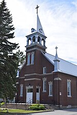
Beloeil, Quebec

Beloeil (; French pronunciation: [bɛlœj]) is a city in Quebec, Canada. It is a suburb of Montreal, on the South Shore and is on the Richelieu River, 32 kilometres (20 mi) east of Montreal. According to the official Commission de toponymie du Québec, the name is written Belœil with an oe ligature; however, other sources avoid the ligature, including the Ministry of Municipal Affairs and the town's own official website.The population as of the Canada 2011 Census was 20,783. It is part of the Regional County Municipality of La Vallée-du-Richelieu, within the Administrative Region of Montérégie. It occupies the west shore of the Richelieu River in front of the Mont Saint-Hilaire. Along with the municipality of McMasterville to the immediate south of Beloeil, and the cities of Mont-Saint-Hilaire and Otterburn Park on the eastern bank of the Richelieu, Beloeil forms an unbroken urban area of over 50,796 inhabitants, which is part of Greater Montreal.Belœil was created as a village in 1903 and became a ville (city) in 1914, but can trace its history through the parish of Saint-Mathieu-de-Belœil, established in 1772, and the seigneurie de Belœil, founded in 1694. Its name probably derives from the old French expression "Quel bel œil!", meaning "What a beautiful view!", generally attributed to Jean-Baptiste Hertel, brother of the first seigneur (lord) of Belœil, Joseph-François Hertel de la Fresnière.
Excerpt from the Wikipedia article Beloeil, Quebec (License: CC BY-SA 3.0, Authors, Images).Beloeil, Quebec
Osloer Straße, Frankfurt am Main Europaviertel (Innenstadt 1)
Geographical coordinates (GPS) Address Nearby Places Show on map
Geographical coordinates (GPS)
| Latitude | Longitude |
|---|---|
| N 45.566666666667 ° | E -73.2 ° |
Address
Tiefgarage Kastor und Pollux
Osloer Straße
60327 Frankfurt am Main, Europaviertel (Innenstadt 1)
Hessen, Deutschland
Open on Google Maps


