Gloucester Street

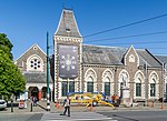
Gloucester Street is a major urban street in central Christchurch in the South Island of New Zealand. It runs for approximately 4.9 kilometres (3.0 mi) from a junction with Rolleston Avenue, directly opposite Christ's College at its western end to the suburbs of Linwood and Avonside in the east. For the majority of its length it runs due west-east, with the section from the central city's eastern edge to Linwood veering to the northeast. The street lies parallel with and one block to the north of Worcester Street. The street's course is interrupted for one block by the Convention Centre Precinct. As it crosses Linwood Avenue, the street turns northeast and narrows, becoming a suburban arterial road. It then turns north, ending at the Avon River / Ōtākaro. A bridge, Dallington Bridge, crosses the river at this point, and the street continues as Gayhurst Road through a former residential area which was razed as a result of the 2011 Christchurch Earthquake.
Excerpt from the Wikipedia article Gloucester Street (License: CC BY-SA 3.0, Authors, Images).Gloucester Street
Rolleston Avenue, Christchurch Central City
Geographical coordinates (GPS) Address Nearby Places Show on map
 Continue reading on Wikipedia
 Geographical coordinates (GPS)
| Latitude | Longitude |
|---|---|
| N -43.53 ° | E 172.62777777778 ° |
Address
Rolleston House
Rolleston Avenue
8011 Christchurch, Central City
Canterbury, New Zealand
Open on Google Maps