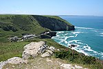
Tintagel Castle (Cornish: Dintagel) is a medieval fortification located on the peninsula of Tintagel Island adjacent to the village of Tintagel (Trevena), North Cornwall in the United Kingdom. The site was possibly occupied in the Romano-British period, as an array of artefacts dating from this period have been found on the peninsula, but as yet no Roman-era structure has been proven to have existed there. It was settled during the early medieval period, when it was probably one of the seasonal residences of the regional king of Dumnonia. A castle was built on the site by Richard, 1st Earl of Cornwall in the 13th century, during the High Middle Ages. It later fell into disrepair and ruin.
Archaeological investigation into the site began in the 19th century as it became a tourist attraction, with visitors coming to see the ruins of Richard's castle. In the 1930s, excavations revealed significant traces of a much earlier high status settlement, which had trading links with the Mediterranean world during the Late Roman period. Two digs in 2016 and 2017 at Tintagel Castle uncovered the outlines of a palace from the 5th or early 6th century (the early medieval period), with evidence of writing and of articles brought in from Spain and from the eastern end of the Mediterranean Sea. The Cornwall Archaeological Unit has a five-year project at this site, with a final report expected in 2021. The items found in the digs have spurred interest before this final report, with two television programmes initially aired in 2018 or 2019, one in the UK by the BBC and another in the US by PBS.The castle has a long association with legends related to King Arthur. This was first recorded in the 12th century when Geoffrey of Monmouth described Tintagel as the place of Arthur's conception in his mythological account of British history, Historia Regum Britanniae. Geoffrey told the story that Arthur's father, King Uther Pendragon, was disguised by Merlin's sorcery to look like Gorlois, Duke of Cornwall, the husband of Igraine, Arthur's mother.Tintagel Castle has been a tourist destination since the mid-19th century. Owned by William, Prince of Wales as part of the landholdings of the Duchy of Cornwall, the site is managed by English Heritage.


