Como, Minneapolis

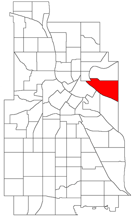
Como is a neighborhood within the University community of Minneapolis. It is sometimes referred to as Southeast Como, due to many of its streets ending in SE, and possibly to differentiate it from the Como neighborhood in neighboring Saint Paul. Its boundaries are East Hennepin Avenue to the north, 33rd Avenue Southeast (the eastern city limit) to the east, the Southeast Industrial Area to the south, and Interstate 35W to the west. Como features many amenities for its residents: Van Cleve Park Community Center, the Como Student Community Co-op, the University Childcare Center, Dar Al-Farooq mosque, SE Christian Church, and the Como Congregational Church building (designed in 1886 by Charles Sedgwick). The #3 busline is convenient to all who live in Como and provides easy transportation to Downtown Minneapolis, all of the University of Minnesota Twin Cities campuses, and Downtown St. Paul. The high-traffic business roads, industrial zones, and active railroads that surround Como contrast sharply with the residential character of the core Como neighborhood. The housing stock consists of modest early 20th-century bungalows and Victorian and twenties-era homes mixed with a scattering of newer duplexes and single family homes. Some areas (e.g. along Como, 15th and Hennepin Avenues) have post-60's two-story walk-up apartment buildings.Commercial activity is focused on Como and East Hennepin Avenues. The neighborhood is served by a services business hub along Como Avenue with grocery stores, dentist, barber shop, coffee houses, restaurants, and auto service station.
Excerpt from the Wikipedia article Como, Minneapolis (License: CC BY-SA 3.0, Authors, Images).Como, Minneapolis
Southeast 24th Avenue, Minneapolis
Geographical coordinates (GPS) Address Nearby Places Show on map
Geographical coordinates (GPS)
| Latitude | Longitude |
|---|---|
| N 44.985 ° | E -93.219 ° |
Address
Southeast 24th Avenue 846
55414 Minneapolis
Minnesota, United States
Open on Google Maps


