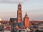
Dom Tower of Utrecht
Bell towers in the NetherlandsBuildings and structures in Utrecht (city)CarillonsCommons category link is locally definedHistory of Utrecht (city) ... and 4 more
Infobox religious building with unknown affiliationRijksmonuments in Utrecht (city)Tourist attractions in Utrecht (province)Towers in the Netherlands

The Dom Tower (Cathedral Tower, Dutch: Domtoren) of Utrecht is the tallest church tower in the Netherlands, at 112.5 metres (368 feet) in height. It is considered the symbol of Utrecht. The tower was part of St. Martin's Cathedral, also known as the Dom Church, and was built between 1321 and 1382, to a design by John of Hainaut. The cathedral was never fully completed due to lack of money. Since the unfinished nave collapsed in 1674, the Dom tower has been a freestanding tower. The tower stands at the spot where the city of Utrecht originated almost 2,000 years ago.
Excerpt from the Wikipedia article Dom Tower of Utrecht (License: CC BY-SA 3.0, Authors, Images).Dom Tower of Utrecht
Domplein, Utrecht
Geographical coordinates (GPS) Address External links Nearby Places Show on map
Geographical coordinates (GPS)
| Latitude | Longitude |
|---|---|
| N 52.09065 ° | E 5.1214 ° |
Address
Domtoren
Domplein
3512 JE Utrecht (Utrecht)
Utrecht, Netherlands
Open on Google Maps


